Montreat geodata
Montreat (North Carolina) is a populated place; located in United States in America/New_York (GMT-4) time zone. With population of 723 people, there are 18471 cities with bigger population in this country. Compared to other cities in United States, 72% of cities are located further ↑North; 64.6% of cities are located further ←West and 92% of cities have lower elevation than Montreat. Note1
Administrative division(s):
- Level 1: North Carolina
- Level 2: Buncombe County
- Level 3: Township of Black Mountain


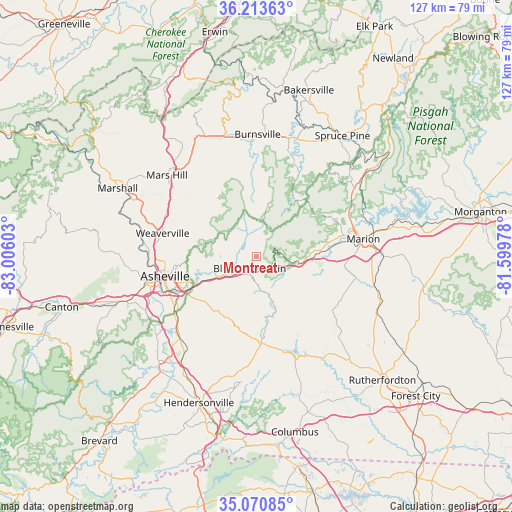
Montreat GPS coordinates[2]
35° 38' 39.408" North, 82° 18' 10.44" West
| Map corner | latitude | longitude |
|---|---|---|
| Upper-left | 36.21363°, | -83.00603° |
| Center: | 35.64428°, | -82.3029° |
| Lower-right: | 35.07085°, | -81.59978° |
| Map W x H: | 127.1×127.1 km | = 79×79mi |
| max Lat: | 71.29058° ⇑72% North |
| Montreat: | 35.64428° |
| min Lat: | ⇓28% South 19.06759° |
| min Long | Montreat | max Long |
| -171.73463° | -82.3029° | -66.98998° |
| W 64.6%⇐ | ⇒35.4% E |
Elevation
Elevation of Montreat is 803 m = 2635 ft, and this is 508.2 m = 1667 ft above average elevation for this country.
| Max E: |
3189 m = 10463 ft | 8% |
| Montreat | 803 m 2635 ft | |
| Avg. | 294.8 m = 967 ft | |
Min E: |
-60 m = -197 ft | 92% |
See also: United States elevation on elevation.city.
Geographical zone
Montreat is located in North temperate zone (between Tropic of Cancer and the Arctic Circle). Distance of this Northern Tropic circle is 1357.4 km =843.4 mi to South.| Distance of | km | miles | from Montreat |
|---|---|---|---|
| North Pole | 6043.8 | 3755.4 | to North |
| Arctic Circle | 3437.9 | 2136.2 | to North |
| Tropic Cancer | 1357.4 | 843.4 | to South |
| Equator | 3963.3 | 2462.7 | to South |


Nearby cities:
15 places around Montreat: (largest is in red/bold)
• Asheville
23.2 km =14.4 mi,  258°
258°
• Biltmore Forest
23.8 km =14.8 mi,  238°
238°
• Black Mountain
3.4 km =2.1 mi,  209°
209°
• Edneyville
28 km =17.4 mi,  187°
187°
• Fairview
16.8 km =10.4 mi, 210°
• Fruitland
28.7 km =17.8 mi,  196°
196°
• Hoopers Creek
27.2 km =16.9 mi, 213°
• Lake Lure
25.6 km =15.9 mi,  159°
159°
• Marion
26.9 km =16.7 mi,  80°
80°
• Old Fort
11.2 km =7 mi,  98°
98°
• Royal Pines
26.9 km =16.7 mi,  225°
225°
• Swannanoa
10.2 km =6.3 mi, 239°
• Weaverville
24 km =14.9 mi,  284°
284°
• West Marion
25.1 km =15.6 mi,  86°
86°
• Woodfin
25.3 km =15.7 mi,  267°
267°
Sources, notices
• [Note1] Compared only with cities in United States existing in our database
• [Src1] Map data: © OpenStreetMap contributors (CC-BY-SA)
• [Src2] Other city data from geonames.org with taken over terms of usage.
• [Src3] Geographical zone / Annual Mean Temperature by Robert A. Rohde @ Wikipedia
