Welcome geodata
Welcome (North Carolina) is a populated place; located in United States in America/New_York (GMT-4) time zone. With population of 4,162 people, there are 8034 cities with bigger population in this country. Compared to other cities in United States, 70.9% of cities are located further ↑North; 71.9% of cities are located further ←West and 65% of cities have lower elevation than Welcome. Note1
Administrative division(s):
- Level 1: North Carolina
- Level 2: Davidson County
- Level 3: Township of Lexington


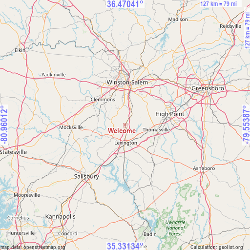
Welcome GPS coordinates[2]
35° 54' 10.512" North, 80° 15' 25.164" West
| Map corner | latitude | longitude |
|---|---|---|
| Upper-left | 36.47041°, | -80.96012° |
| Center: | 35.90292°, | -80.25699° |
| Lower-right: | 35.33134°, | -79.55387° |
| Map W x H: | 126.7×126.7 km | = 78.7×78.7mi |
| max Lat: | 71.29058° ⇑70.9% North |
| Welcome: | 35.90292° |
| min Lat: | ⇓29.1% South 19.06759° |
| min Long | Welcome | max Long |
| -171.73463° | -80.25699° | -66.98998° |
| W 71.9%⇐ | ⇒28.1% E |
Elevation
Elevation of Welcome is 262 m = 860 ft, and this is 32.8 m = 108 ft below average elevation for this country.
| Max E: |
3189 m = 10463 ft | 35% |
| Avg. | 294.8 m = 967 ft | |
| Welcome | 262 m = 860 ft | |
Min E: |
-60 m = -197 ft | 65% |
See also: United States elevation on elevation.city.
Geographical zone
Welcome is located in North temperate zone (between Tropic of Cancer and the Arctic Circle). Distance of this Northern Tropic circle is 1386.1 km =861.3 mi to South.| Distance of | km | miles | from Welcome |
|---|---|---|---|
| North Pole | 6015 | 3737.5 | to North |
| Arctic Circle | 3409.1 | 2118.3 | to North |
| Tropic Cancer | 1386.1 | 861.3 | to South |
| Equator | 3992 | 2480.5 | to South |


Nearby cities:
15 places around Welcome: (largest is in red/bold)
• Advance
14.4 km =8.9 mi,  287°
287°
• Archdale
25.7 km =16 mi,  87°
87°
• Bermuda Run
18.6 km =11.6 mi,  307°
307°
• Clemmons
17.3 km =10.7 mi,  319°
319°
• High Point
23.4 km =14.5 mi,  75°
75°
• Hillsdale
20 km =12.4 mi,  304°
304°
• Lewisville
26.1 km =16.2 mi,  325°
325°
• Lexington
8.8 km =5.5 mi,  177°
177°
• Midway
6.6 km =4.1 mi,  31°
31°
• Southmont
26.1 km =16.2 mi, 181°
• Thomasville
15.9 km =9.9 mi,  98°
98°
• Trinity
24 km =14.9 mi, 92°
• Tyro
14.8 km =9.2 mi,  224°
224°
• Wallburg
16 km =9.9 mi,  41°
41°
• Winston-Salem
21.9 km =13.6 mi,  3°
3°
Sources, notices
• [Note1] Compared only with cities in United States existing in our database
• [Src1] Map data: © OpenStreetMap contributors (CC-BY-SA)
• [Src2] Other city data from geonames.org with taken over terms of usage.
• [Src3] Geographical zone / Annual Mean Temperature by Robert A. Rohde @ Wikipedia
