Lexington geodata
Lexington (North Carolina) is a seat of a second-order administrative division; located in United States in America/New_York (GMT-4) time zone. With population of 19,326 people, there are 2597 cities with bigger population in this country. Compared to other cities in United States, 71.2% of cities are located further ↑North; 71.9% of cities are located further ←West and 61.7% of cities have lower elevation than Lexington. Note1
Administrative division(s):
- Level 1: North Carolina
- Level 2: Davidson County
- Level 3: Township of Lexington


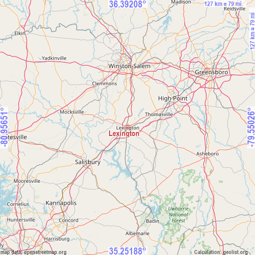
Lexington GPS coordinates[2]
35° 49' 26.508" North, 80° 15' 12.168" West
| Map corner | latitude | longitude |
|---|---|---|
| Upper-left | 36.39208°, | -80.95651° |
| Center: | 35.82403°, | -80.25338° |
| Lower-right: | 35.25188°, | -79.55026° |
| Map W x H: | 126.8×126.8 km | = 78.8×78.8mi |
| max Lat: | 71.29058° ⇑71.2% North |
| Lexington: | 35.82403° |
| min Lat: | ⇓28.8% South 19.06759° |
| min Long | Lexington | max Long |
| -171.73463° | -80.25338° | -66.98998° |
| W 71.9%⇐ | ⇒28.1% E |
Elevation
Elevation of Lexington is 247 m = 810 ft, and this is 47.8 m = 157 ft below average elevation for this country.
| Max E: |
3189 m = 10463 ft | 38.3% |
| Avg. | 294.8 m = 967 ft | |
| Lexington | 247 m = 810 ft | |
Min E: |
-60 m = -197 ft | 61.7% |
See also: United States elevation on elevation.city.
Geographical zone
Lexington is located in North temperate zone (between Tropic of Cancer and the Arctic Circle). Distance of this Northern Tropic circle is 1377.3 km =855.8 mi to South.| Distance of | km | miles | from Lexington |
|---|---|---|---|
| North Pole | 6023.8 | 3743 | to North |
| Arctic Circle | 3417.9 | 2123.8 | to North |
| Tropic Cancer | 1377.3 | 855.8 | to South |
| Equator | 3983.3 | 2475.1 | to South |


Nearby cities:
15 places around Lexington: (largest is in red/bold)
• Advance
19.2 km =11.9 mi,  312°
312°
• Bermuda Run
25.1 km =15.6 mi,  322°
322°
• Clemmons
24.8 km =15.4 mi,  332°
332°
• Denton
24.6 km =15.3 mi,  149°
149°
• East Spencer
22.6 km =14 mi,  225°
225°
• Franklin
24.9 km =15.5 mi,  242°
242°
• Midway
14.7 km =9.1 mi,  12°
12°
• Salisbury
26.2 km =16.3 mi, 229°
• Southmont
17.4 km =10.8 mi,  184°
184°
• Spencer
22 km =13.7 mi, 228°
• Thomasville
16.8 km =10.4 mi,  67°
67°
• Trinity
24.9 km =15.5 mi, 71°
• Tyro
10.9 km =6.8 mi,  261°
261°
• Wallburg
23.1 km =14.4 mi,  26°
26°
• Welcome
8.8 km =5.5 mi,  357°
357°
Sources, notices
• [Note1] Compared only with cities in United States existing in our database
• [Src1] Map data: © OpenStreetMap contributors (CC-BY-SA)
• [Src2] Other city data from geonames.org with taken over terms of usage.
• [Src3] Geographical zone / Annual Mean Temperature by Robert A. Rohde @ Wikipedia
