Wilson geodata
Wilson (North Carolina) is a seat of a second-order administrative division; located in United States in America/New_York (GMT-4) time zone. With population of 49,643 people, there are 961 cities with bigger population in this country. Compared to other cities in United States, 71.7% of cities are located further ↑North; 77.9% of cities are located further ←West and 81.6% of cities have higher elevation than Wilson. Note1
Administrative division(s):
- Level 1: North Carolina
- Level 2: Wilson County
- Level 3: Township of Wilson


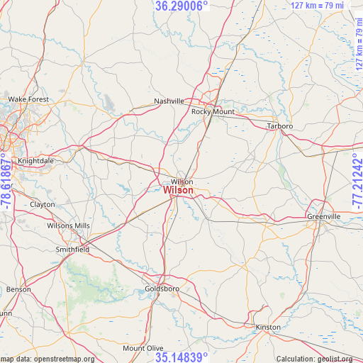
Wilson GPS coordinates[2]
35° 43' 16.572" North, 77° 54' 55.944" West
| Map corner | latitude | longitude |
|---|---|---|
| Upper-left | 36.29006°, | -78.61867° |
| Center: | 35.72127°, | -77.91554° |
| Lower-right: | 35.14839°, | -77.21242° |
| Map W x H: | 126.9×126.9 km | = 78.9×78.9mi |
| max Lat: | 71.29058° ⇑71.7% North |
| Wilson: | 35.72127° |
| min Lat: | ⇓28.3% South 19.06759° |
| min Long | Wilson | max Long |
| -171.73463° | -77.91554° | -66.98998° |
| W 77.9%⇐ | ⇒22.1% E |
Elevation
Elevation of Wilson is 40 m = 131 ft, and this is 254.8 m = 836 ft below average elevation for this country.
| Max E: |
3189 m = 10463 ft | 81.6% |
| Avg. | 294.8 m = 967 ft | |
| Wilson | 40 m = 131 ft | |
Min E: |
-60 m = -197 ft | 18.4% |
See also: Wilson elevation on elevation.city.
Geographical zone
Wilson is located in North temperate zone (between Tropic of Cancer and the Arctic Circle). Distance of this Northern Tropic circle is 1365.9 km =848.7 mi to South.| Distance of | km | miles | from Wilson |
|---|---|---|---|
| North Pole | 6035.2 | 3750.1 | to North |
| Arctic Circle | 3429.3 | 2130.9 | to North |
| Tropic Cancer | 1365.9 | 848.7 | to South |
| Equator | 3971.8 | 2468 | to South |


Nearby cities:
15 places around Wilson: (largest is in red/bold)
• Bailey
19.5 km =12.1 mi,  289°
289°
• Black Creek
9.7 km =6 mi,  189°
189°
• Dortches
32.7 km =20.3 mi,  9°
9°
• Elm City
10.6 km =6.6 mi,  26°
26°
• Fremont
20.3 km =12.6 mi,  195°
195°
• Kenly
23.4 km =14.5 mi,  233°
233°
• Lucama
12 km =7.5 mi, 225°
• Middlesex
27.1 km =16.8 mi, 286°
• Nashville
28.5 km =17.7 mi,  350°
350°
• Pikeville
25.6 km =15.9 mi, 193°
• Pinetops
26.2 km =16.3 mi,  73°
73°
• Rocky Mount
26.6 km =16.5 mi, 25°
• Sharpsburg
18 km =11.2 mi, 25°
• Spring Hope
30.5 km =19 mi,  324°
324°
• Stantonsburg
15.2 km =9.4 mi,  146°
146°
Sources, notices
• [Note1] Compared only with cities in United States existing in our database
• [Src1] Map data: © OpenStreetMap contributors (CC-BY-SA)
• [Src2] Other city data from geonames.org with taken over terms of usage.
• [Src3] Geographical zone / Annual Mean Temperature by Robert A. Rohde @ Wikipedia
