Bailey geodata
Bailey (North Carolina) is a populated place; located in United States in America/New_York (GMT-4) time zone. With population of 565 people, there are 20091 cities with bigger population in this country. Compared to other cities in United States, 71.4% of cities are located further ↑North; 77.6% of cities are located further ←West and 75.8% of cities have higher elevation than Bailey. Note1
Administrative division(s):
- Level 1: North Carolina
- Level 2: Nash County
- Level 3: Township of Bailey


Bailey GPS coordinates[2]
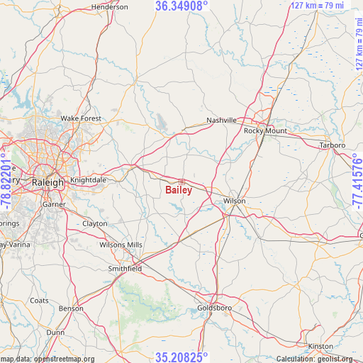
35° 46' 50.556" North, 78° 7' 7.968" West
| Map corner | latitude | longitude |
|---|---|---|
| Upper-left | 36.34908°, | -78.82201° |
| Center: | 35.78071°, | -78.11888° |
| Lower-right: | 35.20825°, | -77.41576° |
| Map W x H: | 126.8×126.8 km | = 78.8×78.8mi |
| max Lat: | 71.29058° ⇑71.4% North |
| Bailey: | 35.78071° |
| min Lat: | ⇓28.6% South 19.06759° |
| min Long | Bailey | max Long |
| -171.73463° | -78.11888° | -66.98998° |
| W 77.6%⇐ | ⇒22.4% E |
Elevation
Elevation of Bailey is 67 m = 220 ft, and this is 227.8 m = 747 ft below average elevation for this country.
| Max E: |
3189 m = 10463 ft | 75.8% |
| Avg. | 294.8 m = 967 ft | |
| Bailey | 67 m = 220 ft | |
Min E: |
-60 m = -197 ft | 24.2% |
See also: United States elevation on elevation.city.
Geographical zone
Bailey is located in North temperate zone (between Tropic of Cancer and the Arctic Circle). Distance of this Northern Tropic circle is 1372.5 km =852.8 mi to South.| Distance of | km | miles | from Bailey |
|---|---|---|---|
| North Pole | 6028.6 | 3746 | to North |
| Arctic Circle | 3422.7 | 2126.8 | to North |
| Tropic Cancer | 1372.5 | 852.8 | to South |
| Equator | 3978.4 | 2472.1 | to South |


Nearby cities:
15 places around Bailey: (largest is in red/bold)
• Archer Lodge
25.1 km =15.6 mi,  247°
247°
• Black Creek
23.3 km =14.5 mi,  133°
133°
• Elm City
23.2 km =14.4 mi,  82°
82°
• Fremont
29.2 km =18.1 mi,  153°
153°
• Kenly
20.5 km =12.7 mi,  181°
181°
• Lucama
18 km =11.2 mi, 146°
• Middlesex
7.7 km =4.8 mi,  277°
277°
• Nashville
25.6 km =15.9 mi,  32°
32°
• Selma
31 km =19.3 mi,  208°
208°
• Sharpsburg
27.8 km =17.3 mi,  69°
69°
• Spring Hope
18.3 km =11.4 mi,  1°
1°
• Wendell
22.6 km =14 mi,  270°
270°
• Wilson
19.5 km =12.1 mi,  109°
109°
• Wilsons Mills
30.6 km =19 mi,  224°
224°
• Zebulon
18.3 km =11.4 mi,  285°
285°
Sources, notices
• [Note1] Compared only with cities in United States existing in our database
• [Src1] Map data: © OpenStreetMap contributors (CC-BY-SA)
• [Src2] Other city data from geonames.org with taken over terms of usage.
• [Src3] Geographical zone / Annual Mean Temperature by Robert A. Rohde @ Wikipedia
