Kenly geodata
Kenly (North Carolina) is a populated place; located in United States in America/New_York (GMT-4) time zone. With population of 1,450 people, there are 13877 cities with bigger population in this country. Compared to other cities in United States, 72.2% of cities are located further ↑North; 77.6% of cities are located further ←West and 76.5% of cities have higher elevation than Kenly. Note1
Administrative division(s):
- Level 1: North Carolina
- Level 2: Johnston County
- Level 3: Township of Beulah


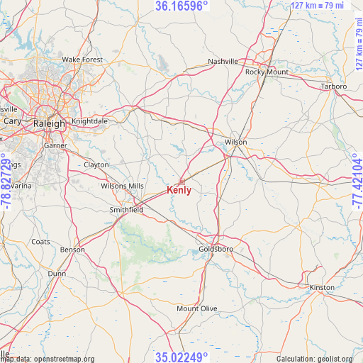
Kenly GPS coordinates[2]
35° 35' 46.572" North, 78° 7' 26.976" West
| Map corner | latitude | longitude |
|---|---|---|
| Upper-left | 36.16596°, | -78.82729° |
| Center: | 35.59627°, | -78.12416° |
| Lower-right: | 35.02249°, | -77.42104° |
| Map W x H: | 127.1×127.1 km | = 79×79mi |
| max Lat: | 71.29058° ⇑72.2% North |
| Kenly: | 35.59627° |
| min Lat: | ⇓27.8% South 19.06759° |
| min Long | Kenly | max Long |
| -171.73463° | -78.12416° | -66.98998° |
| W 77.6%⇐ | ⇒22.4% E |
Elevation
Elevation of Kenly is 63 m = 207 ft, and this is 231.8 m = 760 ft below average elevation for this country.
| Max E: |
3189 m = 10463 ft | 76.5% |
| Avg. | 294.8 m = 967 ft | |
| Kenly | 63 m = 207 ft | |
Min E: |
-60 m = -197 ft | 23.5% |
See also: United States elevation on elevation.city.
Geographical zone
Kenly is located in North temperate zone (between Tropic of Cancer and the Arctic Circle). Distance of this Northern Tropic circle is 1352 km =840.1 mi to South.| Distance of | km | miles | from Kenly |
|---|---|---|---|
| North Pole | 6049.1 | 3758.7 | to North |
| Arctic Circle | 3443.2 | 2139.5 | to North |
| Tropic Cancer | 1352 | 840.1 | to South |
| Equator | 3957.9 | 2459.3 | to South |


Nearby cities:
15 places around Kenly: (largest is in red/bold)
• Archer Lodge
25.2 km =15.7 mi,  295°
295°
• Bailey
20.5 km =12.7 mi,  1°
1°
• Black Creek
17.8 km =11.1 mi,  75°
75°
• Fremont
14.7 km =9.1 mi,  112°
112°
• Goldsboro
26.3 km =16.3 mi,  153°
153°
• Lucama
11.7 km =7.3 mi,  62°
62°
• Middlesex
22.7 km =14.1 mi,  341°
341°
• Pikeville
16.9 km =10.5 mi,  130°
130°
• Pine Level
14.3 km =8.9 mi,  229°
229°
• Princeton
14.9 km =9.3 mi,  192°
192°
• Selma
15.9 km =9.9 mi,  245°
245°
• Smithfield
21.8 km =13.5 mi,  243°
243°
• Stantonsburg
27.2 km =16.9 mi,  87°
87°
• Wilson
23.4 km =14.5 mi,  53°
53°
• Wilsons Mills
21 km =13 mi,  266°
266°
Sources, notices
• [Note1] Compared only with cities in United States existing in our database
• [Src1] Map data: © OpenStreetMap contributors (CC-BY-SA)
• [Src2] Other city data from geonames.org with taken over terms of usage.
• [Src3] Geographical zone / Annual Mean Temperature by Robert A. Rohde @ Wikipedia
