Country Lake Estates geodata
Country Lake Estates (New Jersey) is a populated place; located in United States in America/New_York (GMT-4) time zone. With population of 3,943 people, there are 8273 cities with bigger population in this country. Compared to other cities in United States, 53% of cities are located further ↓South; 88.4% of cities are located further ←West and 85.1% of cities have higher elevation than Country Lake Estates. Note1
Administrative division(s):
- Level 1: New Jersey
- Level 2: Burlington County
- Level 3: Township of Pemberton


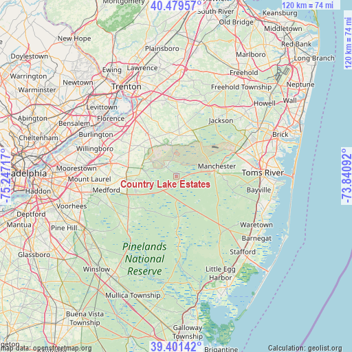
Country Lake Estates GPS coordinates[2]
39° 56' 33.432" North, 74° 32' 38.544" West
| Map corner | latitude | longitude |
|---|---|---|
| Upper-left | 40.47957°, | -75.24717° |
| Center: | 39.94262°, | -74.54404° |
| Lower-right: | 39.40142°, | -73.84092° |
| Map W x H: | 119.9×119.9 km | = 74.5×74.5mi |
| max Lat: | 71.29058° ⇑47% North |
| Country Lake Estates: | 39.94262° |
| min Lat: | ⇓53% South 19.06759° |
| min Long | Country Lake Es | max Long |
| -171.73463° | -74.54404° | -66.98998° |
| W 88.4%⇐ | ⇒11.6% E |
Elevation
Elevation of Country Lake Estates is 28 m = 92 ft, and this is 266.8 m = 875 ft below average elevation for this country.
| Max E: |
3189 m = 10463 ft | 85.1% |
| Avg. | 294.8 m = 967 ft | |
| Country Lake Estates | 28 m = 92 ft | |
Min E: |
-60 m = -197 ft | 14.9% |
See also: United States elevation on elevation.city.
Geographical zone
Country Lake Estates is located in North temperate zone (between Tropic of Cancer and the Arctic Circle). Distance of this Northern Tropic circle is 1835.3 km =1140.4 mi to South.| Distance of | km | miles | from Country Lake Estates |
|---|---|---|---|
| North Pole | 5565.9 | 3458.5 | to North |
| Arctic Circle | 2960 | 1839.3 | to North |
| Tropic Cancer | 1835.3 | 1140.4 | to South |
| Equator | 4441.2 | 2759.6 | to South |


Nearby cities:
15 places around Country Lake Estates: (largest is in red/bold)
• Browns Mills
4.7 km =2.9 mi,  315°
315°
• Cedar Glen Lakes
12.3 km =7.6 mi,  84°
84°
• Crestwood Village
15.6 km =9.7 mi,  87°
87°
• Fort Dix
11.6 km =7.2 mi,  326°
326°
• Lakehurst
21.4 km =13.3 mi,  68°
68°
• Leisuretowne
14.6 km =9.1 mi,  247°
247°
• Magnolia
10 km =6.2 mi,  274°
274°
• McGuire AFB
11.3 km =7 mi,  343°
343°
• New Egypt
13.9 km =8.6 mi,  4°
4°
• Pemberton
12.3 km =7.6 mi,  285°
285°
• Pemberton Heights
11.7 km =7.3 mi,  280°
280°
• Pine Ridge at Crestwood
19.6 km =12.2 mi, 86°
• Presidential Lakes Estates
3.7 km =2.3 mi,  208°
208°
• Vincentown
17.5 km =10.9 mi, 266°
• Wrightstown
12.2 km =7.6 mi, 328°
Sources, notices
• [Note1] Compared only with cities in United States existing in our database
• [Src1] Map data: © OpenStreetMap contributors (CC-BY-SA)
• [Src2] Other city data from geonames.org with taken over terms of usage.
• [Src3] Geographical zone / Annual Mean Temperature by Robert A. Rohde @ Wikipedia
