Cedar Glen Lakes geodata
Cedar Glen Lakes (New Jersey) is a populated place; located in United States in America/New_York (GMT-4) time zone. With population of 1,421 people, there are 14009 cities with bigger population in this country. Compared to other cities in United States, 53.1% of cities are located further ↓South; 88.8% of cities are located further ←West and 79.3% of cities have higher elevation than Cedar Glen Lakes. Note1
Administrative division(s):
- Level 1: New Jersey
- Level 2: Ocean County
- Level 3: Township of Manchester


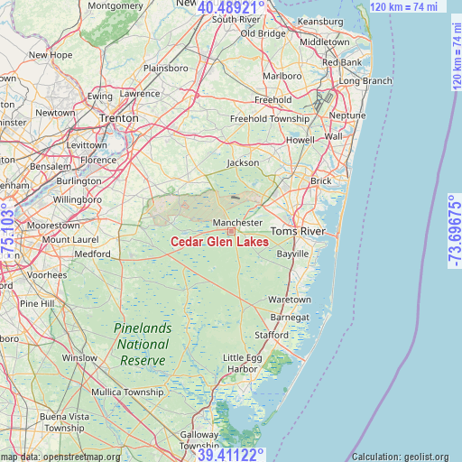
Cedar Glen Lakes GPS coordinates[2]
39° 57' 8.424" North, 74° 23' 59.532" West
| Map corner | latitude | longitude |
|---|---|---|
| Upper-left | 40.48921°, | -75.103° |
| Center: | 39.95234°, | -74.39987° |
| Lower-right: | 39.41122°, | -73.69675° |
| Map W x H: | 119.9×119.9 km | = 74.5×74.5mi |
| max Lat: | 71.29058° ⇑46.9% North |
| Cedar Glen Lakes: | 39.95234° |
| min Lat: | ⇓53.1% South 19.06759° |
| min Long | Cedar Glen Lake | max Long |
| -171.73463° | -74.39987° | -66.98998° |
| W 88.8%⇐ | ⇒11.2% E |
Elevation
Elevation of Cedar Glen Lakes is 50 m = 164 ft, and this is 244.8 m = 803 ft below average elevation for this country.
| Max E: |
3189 m = 10463 ft | 79.3% |
| Avg. | 294.8 m = 967 ft | |
| Cedar Glen Lakes | 50 m = 164 ft | |
Min E: |
-60 m = -197 ft | 20.7% |
See also: United States elevation on elevation.city.
Geographical zone
Cedar Glen Lakes is located in North temperate zone (between Tropic of Cancer and the Arctic Circle). Distance of this Northern Tropic circle is 1836.4 km =1141.1 mi to South.| Distance of | km | miles | from Cedar Glen Lakes |
|---|---|---|---|
| North Pole | 5564.8 | 3457.8 | to North |
| Arctic Circle | 2958.9 | 1838.6 | to North |
| Tropic Cancer | 1836.4 | 1141.1 | to South |
| Equator | 4442.3 | 2760.3 | to South |


Nearby cities:
15 places around Cedar Glen Lakes: (largest is in red/bold)
• Browns Mills
15.8 km =9.8 mi,  278°
278°
• Cedar Glen West
13.5 km =8.4 mi,  42°
42°
• Country Lake Estates
12.3 km =7.6 mi,  264°
264°
• Crestwood Village
3.4 km =2.1 mi,  97°
97°
• Holiday City South
13.8 km =8.6 mi,  89°
89°
• Holiday City-Berkeley
10.5 km =6.5 mi,  83°
83°
• Holiday Heights
12.5 km =7.8 mi, 93°
• Lakehurst
10.2 km =6.3 mi,  47°
47°
• Leisure Knoll
11.8 km =7.3 mi, 51°
• Leisure Village West-Pine Lake Park
12.8 km =8 mi,  63°
63°
• Pine Lake Park
13.5 km =8.4 mi,  65°
65°
• Pine Ridge at Crestwood
7.2 km =4.5 mi, 88°
• Presidential Lakes Estates
14.7 km =9.1 mi,  253°
253°
• Silver Ridge
15.5 km =9.6 mi, 87°
• South Toms River
16.7 km =10.4 mi, 93°
Sources, notices
• [Note1] Compared only with cities in United States existing in our database
• [Src1] Map data: © OpenStreetMap contributors (CC-BY-SA)
• [Src2] Other city data from geonames.org with taken over terms of usage.
• [Src3] Geographical zone / Annual Mean Temperature by Robert A. Rohde @ Wikipedia
