Vincentown geodata
Vincentown (New Jersey) is a populated place; located in United States in America/New_York (GMT-4) time zone. With population of 24,664 people, there are 2044 cities with bigger population in this country. Compared to other cities in United States, 52.8% of cities are located further ↓South; 87.9% of cities are located further ←West and 91% of cities have higher elevation than Vincentown. Note1
Administrative division(s):
- Level 1: New Jersey
- Level 2: Burlington County
- Level 3: Township of Southampton


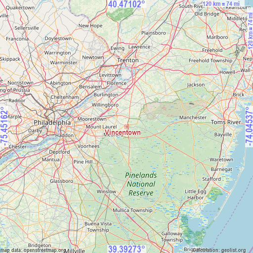
Vincentown GPS coordinates[2]
39° 56' 2.4" North, 74° 44' 54.564" West
| Map corner | latitude | longitude |
|---|---|---|
| Upper-left | 40.47102°, | -75.45162° |
| Center: | 39.934°, | -74.74849° |
| Lower-right: | 39.39273°, | -74.04537° |
| Map W x H: | 119.9×119.9 km | = 74.5×74.5mi |
| max Lat: | 71.29058° ⇑47.2% North |
| Vincentown: | 39.934° |
| min Lat: | ⇓52.8% South 19.06759° |
| min Long | Vincentown | max Long |
| -171.73463° | -74.74849° | -66.98998° |
| W 87.9%⇐ | ⇒12.1% E |
Elevation
Elevation of Vincentown is 14 m = 46 ft, and this is 280.8 m = 921 ft below average elevation for this country.
| Max E: |
3189 m = 10463 ft | 91% |
| Avg. | 294.8 m = 967 ft | |
| Vincentown | 14 m = 46 ft | |
Min E: |
-60 m = -197 ft | 9% |
See also: United States elevation on elevation.city.
Geographical zone
Vincentown is located in North temperate zone (between Tropic of Cancer and the Arctic Circle). Distance of this Northern Tropic circle is 1834.3 km =1139.8 mi to South.| Distance of | km | miles | from Vincentown |
|---|---|---|---|
| North Pole | 5566.8 | 3459 | to North |
| Arctic Circle | 2960.9 | 1839.8 | to North |
| Tropic Cancer | 1834.3 | 1139.8 | to South |
| Equator | 4440.2 | 2759 | to South |


Nearby cities:
15 places around Vincentown: (largest is in red/bold)
• Browns Mills
14.7 km =9.1 mi,  73°
73°
• Country Lake Estates
17.5 km =10.9 mi,  86°
86°
• Fort Dix
15.4 km =9.6 mi,  46°
46°
• Leisuretowne
6.1 km =3.8 mi,  139°
139°
• Magnolia
7.7 km =4.8 mi,  76°
76°
• Marlton
15.5 km =9.6 mi,  252°
252°
• Medford Lakes
9.6 km =6 mi,  208°
208°
• Mount Holly
7.3 km =4.5 mi,  332°
332°
• Mount Laurel
12.2 km =7.6 mi,  270°
270°
• Pemberton
7 km =4.3 mi, 52°
• Pemberton Heights
6.7 km =4.2 mi,  61°
61°
• Presidential Lakes Estates
15.8 km =9.8 mi,  98°
98°
• Ramblewood
16.7 km =10.4 mi, 267°
• Willingboro
14.6 km =9.1 mi,  315°
315°
• Wrightstown
15.9 km =9.9 mi,  44°
44°
Sources, notices
• [Note1] Compared only with cities in United States existing in our database
• [Src1] Map data: © OpenStreetMap contributors (CC-BY-SA)
• [Src2] Other city data from geonames.org with taken over terms of usage.
• [Src3] Geographical zone / Annual Mean Temperature by Robert A. Rohde @ Wikipedia
