Jackson geodata
Jackson (New Jersey) is a populated place; located in United States in America/New_York (GMT-4) time zone. With population of 54,856 people, there are 844 cities with bigger population in this country. Compared to other cities in United States, 51.3% of cities are located further ↓South; 87.7% of cities are located further ←West and 81.6% of cities have higher elevation than Jackson. Note1
Administrative division(s):
- Level 1: New Jersey
- Level 2: Camden County
- Level 3: Township of Waterford


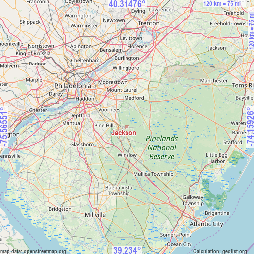
Jackson GPS coordinates[2]
39° 46' 35.4" North, 74° 51' 44.568" West
| Map corner | latitude | longitude |
|---|---|---|
| Upper-left | 40.31476°, | -75.56551° |
| Center: | 39.7765°, | -74.86238° |
| Lower-right: | 39.234°, | -74.15926° |
| Map W x H: | 120.2×120.2 km | = 74.7×74.7mi |
| max Lat: | 71.29058° ⇑48.7% North |
| Jackson: | 39.7765° |
| min Lat: | ⇓51.3% South 19.06759° |
| min Long | Jackson | max Long |
| -171.73463° | -74.86238° | -66.98998° |
| W 87.7%⇐ | ⇒12.3% E |
Elevation
Elevation of Jackson is 40 m = 131 ft, and this is 254.8 m = 836 ft below average elevation for this country.
| Max E: |
3189 m = 10463 ft | 81.6% |
| Avg. | 294.8 m = 967 ft | |
| Jackson | 40 m = 131 ft | |
Min E: |
-60 m = -197 ft | 18.4% |
See also: Jackson elevation on elevation.city.
Geographical zone
Jackson is located in North temperate zone (between Tropic of Cancer and the Arctic Circle). Distance of this Northern Tropic circle is 1816.8 km =1128.9 mi to South.| Distance of | km | miles | from Jackson |
|---|---|---|---|
| North Pole | 5584.3 | 3469.9 | to North |
| Arctic Circle | 2978.4 | 1850.7 | to North |
| Tropic Cancer | 1816.8 | 1128.9 | to South |
| Equator | 4422.7 | 2748.1 | to South |


Nearby cities:
15 places around Jackson: (largest is in red/bold)
• Atco
2.3 km =1.4 mi,  250°
250°
• Berlin
5.9 km =3.7 mi,  286°
286°
• Chesilhurst
5.2 km =3.2 mi,  197°
197°
• Clementon
11 km =6.8 mi, 290°
• Echelon
13.9 km =8.6 mi,  305°
305°
• Florence
6.7 km =4.2 mi,  225°
225°
• Gibbsboro
11.1 km =6.9 mi, 308°
• Laurel Springs
13.2 km =8.2 mi, 291°
• Lindenwold
12.7 km =7.9 mi, 294°
• Marlton
13.7 km =8.5 mi,  338°
338°
• Medford Lakes
10.4 km =6.5 mi,  29°
29°
• Pine Hill
11.1 km =6.9 mi,  274°
274°
• Sicklerville
11.3 km =7 mi, 234°
• Stratford
14.2 km =8.8 mi, 293°
• Williamstown
15.2 km =9.4 mi, 228°
Sources, notices
• [Note1] Compared only with cities in United States existing in our database
• [Src1] Map data: © OpenStreetMap contributors (CC-BY-SA)
• [Src2] Other city data from geonames.org with taken over terms of usage.
• [Src3] Geographical zone / Annual Mean Temperature by Robert A. Rohde @ Wikipedia
