Marlton geodata
Marlton (New Jersey) is a populated place; located in United States in America/New_York (GMT-4) time zone. With population of 10,133 people, there are 4425 cities with bigger population in this country. Compared to other cities in United States, 52.4% of cities are located further ↓South; 87.6% of cities are located further ←West and 82.9% of cities have higher elevation than Marlton. Note1
Administrative division(s):
- Level 1: New Jersey
- Level 2: Burlington County
- Level 3: Township of Evesham


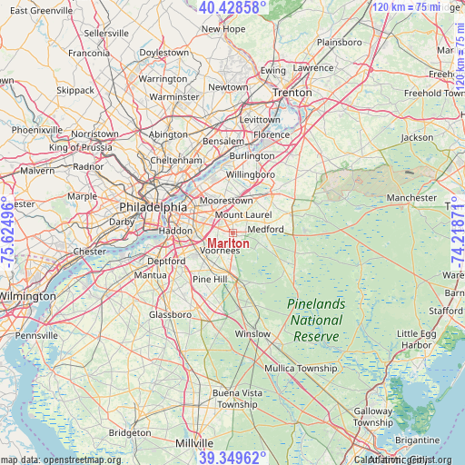
Marlton GPS coordinates[2]
39° 53' 28.392" North, 74° 55' 18.588" West
| Map corner | latitude | longitude |
|---|---|---|
| Upper-left | 40.42858°, | -75.62496° |
| Center: | 39.89122°, | -74.92183° |
| Lower-right: | 39.34962°, | -74.21871° |
| Map W x H: | 120×120 km | = 74.6×74.6mi |
| max Lat: | 71.29058° ⇑47.6% North |
| Marlton: | 39.89122° |
| min Lat: | ⇓52.4% South 19.06759° |
| min Long | Marlton | max Long |
| -171.73463° | -74.92183° | -66.98998° |
| W 87.6%⇐ | ⇒12.4% E |
Elevation
Elevation of Marlton is 35 m = 115 ft, and this is 259.8 m = 852 ft below average elevation for this country.
| Max E: |
3189 m = 10463 ft | 82.9% |
| Avg. | 294.8 m = 967 ft | |
| Marlton | 35 m = 115 ft | |
Min E: |
-60 m = -197 ft | 17.1% |
See also: United States elevation on elevation.city.
Geographical zone
Marlton is located in North temperate zone (between Tropic of Cancer and the Arctic Circle). Distance of this Northern Tropic circle is 1829.6 km =1136.9 mi to South.| Distance of | km | miles | from Marlton |
|---|---|---|---|
| North Pole | 5571.6 | 3462 | to North |
| Arctic Circle | 2965.7 | 1842.8 | to North |
| Tropic Cancer | 1829.6 | 1136.9 | to South |
| Equator | 4435.5 | 2756.1 | to South |


Nearby cities:
15 places around Marlton: (largest is in red/bold)
• Ashland
7.8 km =4.8 mi,  246°
246°
• Brookfield
8.1 km =5 mi,  263°
263°
• Cherry Hill Mall
8.9 km =5.5 mi,  303°
303°
• Echelon
7.9 km =4.9 mi,  232°
232°
• Ellisburg
8 km =5 mi,  288°
288°
• Gibbsboro
6.9 km =4.3 mi,  211°
211°
• Greentree
3 km =1.9 mi,  282°
282°
• Kingston Estates
6.7 km =4.2 mi, 302°
• Lawnside
9.5 km =5.9 mi, 253°
• Lindenwold
9.9 km =6.2 mi,  221°
221°
• Maple Shade
9.1 km =5.7 mi,  318°
318°
• Moorestown-Lenola
9.1 km =5.7 mi,  336°
336°
• Mount Laurel
5.4 km =3.4 mi,  28°
28°
• Ramblewood
4.6 km =2.9 mi, 335°
• Springdale
4 km =2.5 mi, 288°
Sources, notices
• [Note1] Compared only with cities in United States existing in our database
• [Src1] Map data: © OpenStreetMap contributors (CC-BY-SA)
• [Src2] Other city data from geonames.org with taken over terms of usage.
• [Src3] Geographical zone / Annual Mean Temperature by Robert A. Rohde @ Wikipedia
