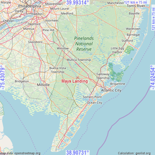
Mays Landing geodata
Mays Landing (New Jersey) is a seat of a second-order administrative division; located in United States in America/New_York (GMT-4) time zone. With population of 2,135 people, there are 11514 cities with bigger population in this country. Compared to other cities in United States, 51.2% of cities are located further ↑North; 88% of cities are located further ←West and 95.7% of cities have higher elevation than Mays Landing. Note1
Administrative division(s):
- Level 1: New Jersey
- Level 2: Atlantic County
- Level 3: Township of Hamilton


Mays Landing GPS coordinates[2]
39° 27' 8.424" North, 74° 43' 39.576" West
| Map corner | latitude | longitude |
|---|---|---|
| Upper-left | 39.99314°, | -75.43079° |
| Center: | 39.45234°, | -74.72766° |
| Lower-right: | 38.90731°, | -74.02454° |
| Map W x H: | 120.7×120.7 km | = 75×75mi |
| max Lat: | 71.29058° ⇑51.2% North |
| Mays Landing: | 39.45234° |
| min Lat: | ⇓48.8% South 19.06759° |
| min Long | Mays Landing | max Long |
| -171.73463° | -74.72766° | -66.98998° |
| W 88%⇐ | ⇒12% E |
Elevation
Elevation of Mays Landing is 8 m = 26 ft, and this is 286.8 m = 941 ft below average elevation for this country.
| Max E: |
3189 m = 10463 ft | 95.7% |
| Avg. | 294.8 m = 967 ft | |
| Mays Landing | 8 m = 26 ft | |
Min E: |
-60 m = -197 ft | 4.3% |
See also: United States elevation on elevation.city.
Geographical zone
Mays Landing is located in North temperate zone (between Tropic of Cancer and the Arctic Circle). Distance of this Northern Tropic circle is 1780.8 km =1106.5 mi to South.| Distance of | km | miles | from Mays Landing |
|---|---|---|---|
| North Pole | 5620.4 | 3492.4 | to North |
| Arctic Circle | 3014.5 | 1873.1 | to North |
| Tropic Cancer | 1780.8 | 1106.5 | to South |
| Equator | 4386.7 | 2725.8 | to South |


Nearby cities:
15 places around Mays Landing: (largest is in red/bold)
• Absecon
20.1 km =12.5 mi,  97°
97°
• Buena
18.2 km =11.3 mi,  291°
291°
• Collings Lakes
20.7 km =12.9 mi,  320°
320°
• Egg Harbor City
10.9 km =6.8 mi,  38°
38°
• Elwood
13.8 km =8.6 mi,  3°
3°
• Estell Manor
4.7 km =2.9 mi,  195°
195°
• Folsom
19.4 km =12.1 mi,  329°
329°
• Hammonton
21.5 km =13.4 mi,  342°
342°
• Linwood
18.1 km =11.2 mi,  133°
133°
• Longport
23.2 km =14.4 mi, 131°
• Northfield
17.8 km =11.1 mi,  120°
120°
• Pleasantville
18.8 km =11.7 mi,  111°
111°
• Pomona
13.4 km =8.3 mi,  77°
77°
• Port Republic
22.1 km =13.7 mi,  69°
69°
• Somers Point
18.8 km =11.7 mi,  142°
142°
Sources, notices
• [Note1] Compared only with cities in United States existing in our database
• [Src1] Map data: © OpenStreetMap contributors (CC-BY-SA)
• [Src2] Other city data from geonames.org with taken over terms of usage.
• [Src3] Geographical zone / Annual Mean Temperature by Robert A. Rohde @ Wikipedia
