Blacklick Estates geodata
Blacklick Estates (Ohio) is a populated place; located in United States in America/New_York (GMT-4) time zone. With population of 8,682 people, there are 4932 cities with bigger population in this country. Compared to other cities in United States, 52.5% of cities are located further ↓South; 62.4% of cities are located further ←West and 58.2% of cities have lower elevation than Blacklick Estates. Note1


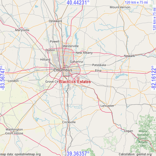
Blacklick Estates GPS coordinates[2]
39° 54' 18.216" North, 82° 51' 51.624" West
| Map corner | latitude | longitude |
|---|---|---|
| Upper-left | 40.44231°, | -83.56747° |
| Center: | 39.90506°, | -82.86434° |
| Lower-right: | 39.36357°, | -82.16122° |
| Map W x H: | 119.9×119.9 km | = 74.5×74.5mi |
| max Lat: | 71.29058° ⇑47.5% North |
| Blacklick Estates: | 39.90506° |
| min Lat: | ⇓52.5% South 19.06759° |
| min Long | Blacklick Estat | max Long |
| -171.73463° | -82.86434° | -66.98998° |
| W 62.4%⇐ | ⇒37.6% E |
Elevation
Elevation of Blacklick Estates is 231 m = 758 ft, and this is 63.8 m = 209 ft below average elevation for this country.
| Max E: |
3189 m = 10463 ft | 41.8% |
| Avg. | 294.8 m = 967 ft | |
| Blacklick Estates | 231 m = 758 ft | |
Min E: |
-60 m = -197 ft | 58.2% |
See also: United States elevation on elevation.city.
Geographical zone
Blacklick Estates is located in North temperate zone (between Tropic of Cancer and the Arctic Circle). Distance of this Northern Tropic circle is 1831.1 km =1137.8 mi to South.| Distance of | km | miles | from Blacklick Estates |
|---|---|---|---|
| North Pole | 5570 | 3461 | to North |
| Arctic Circle | 2964.1 | 1841.8 | to North |
| Tropic Cancer | 1831.1 | 1137.8 | to South |
| Equator | 4437 | 2757 | to South |


Nearby cities:
15 places around Blacklick Estates: (largest is in red/bold)
• Bexley
9.5 km =5.9 mi,  318°
318°
• Canal Winchester
8.6 km =5.3 mi,  143°
143°
• Carroll
18.3 km =11.4 mi,  130°
130°
• Columbus
13.1 km =8.1 mi,  298°
298°
• Etna
16.6 km =10.3 mi,  69°
69°
• Gahanna
12.8 km =8 mi,  354°
354°
• Grandview Heights
17.2 km =10.7 mi, 298°
• Groveport
3.4 km =2.1 mi,  209°
209°
• Lithopolis
12.4 km =7.7 mi,  156°
156°
• Obetz
7.9 km =4.9 mi,  248°
248°
• Pickerington
9.7 km =6 mi,  103°
103°
• Reynoldsburg
7.1 km =4.4 mi,  38°
38°
• Urbancrest
19 km =11.8 mi,  267°
267°
• Valley View
19 km =11.8 mi,  290°
290°
• Whitehall
7.1 km =4.4 mi, 345°
Sources, notices
• [Note1] Compared only with cities in United States existing in our database
• [Src1] Map data: © OpenStreetMap contributors (CC-BY-SA)
• [Src2] Other city data from geonames.org with taken over terms of usage.
• [Src3] Geographical zone / Annual Mean Temperature by Robert A. Rohde @ Wikipedia
