Elmwood Place geodata
Elmwood Place (Ohio) is a populated place; located in United States in America/New_York (GMT-4) time zone. With population of 2,164 people, there are 11429 cities with bigger population in this country. Compared to other cities in United States, 53.2% of cities are located further ↑North; 57.4% of cities are located further ←West and 59% of cities have higher elevation than Elmwood Place. Note1
Administrative division(s):
- Level 1: Ohio
- Level 2: Hamilton County
- Level 3: Village of Elmwood Place


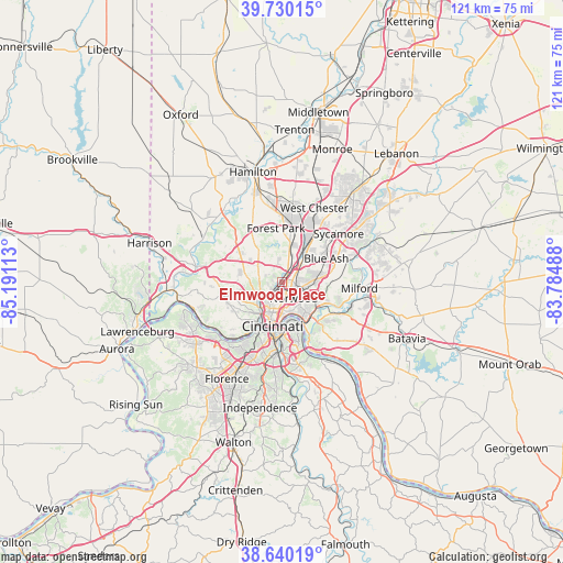
Elmwood Place GPS coordinates[2]
39° 11' 14.208" North, 84° 29' 16.8" West
| Map corner | latitude | longitude |
|---|---|---|
| Upper-left | 39.73015°, | -85.19113° |
| Center: | 39.18728°, | -84.488° |
| Lower-right: | 38.64019°, | -83.78488° |
| Map W x H: | 121.2×121.2 km | = 75.3×75.3mi |
| max Lat: | 71.29058° ⇑53.2% North |
| Elmwood Place: | 39.18728° |
| min Lat: | ⇓46.8% South 19.06759° |
| min Long | Elmwood Place | max Long |
| -171.73463° | -84.488° | -66.98998° |
| W 57.4%⇐ | ⇒42.6% E |
Elevation
Elevation of Elmwood Place is 160 m = 525 ft, and this is 134.8 m = 442 ft below average elevation for this country.
| Max E: |
3189 m = 10463 ft | 59% |
| Avg. | 294.8 m = 967 ft | |
| Elmwood Place | 160 m = 525 ft | |
Min E: |
-60 m = -197 ft | 41% |
See also: United States elevation on elevation.city.
Geographical zone
Elmwood Place is located in North temperate zone (between Tropic of Cancer and the Arctic Circle). Distance of this Northern Tropic circle is 1751.3 km =1088.2 mi to South.| Distance of | km | miles | from Elmwood Place |
|---|---|---|---|
| North Pole | 5649.8 | 3510.6 | to North |
| Arctic Circle | 3044 | 1891.5 | to North |
| Tropic Cancer | 1751.3 | 1088.2 | to South |
| Equator | 4357.2 | 2707.4 | to South |


Nearby cities:
15 places around Elmwood Place: (largest is in red/bold)
• Amberley
5.5 km =3.4 mi,  69°
69°
• Arlington Heights
4.2 km =2.6 mi,  42°
42°
• Cincinnati
7.1 km =4.4 mi,  198°
198°
• Finneytown
3.2 km =2 mi,  297°
297°
• Golf Manor
3.6 km =2.2 mi,  90°
90°
• Lincoln Heights
6.4 km =4 mi,  25°
25°
• Lockland
5.3 km =3.3 mi, 29°
• Mount Healthy
7.2 km =4.5 mi,  316°
316°
• North College Hill
6.4 km =4 mi, 302°
• Norwood
4.3 km =2.7 mi,  145°
145°
• Pleasant Hills
6.3 km =3.9 mi,  329°
329°
• Reading
5.7 km =3.5 mi, 44°
• Saint Bernard
2.4 km =1.5 mi, 201°
• Woodlawn
7.4 km =4.6 mi,  12°
12°
• Wyoming
5.2 km =3.2 mi,  21°
21°
Sources, notices
• [Note1] Compared only with cities in United States existing in our database
• [Src1] Map data: © OpenStreetMap contributors (CC-BY-SA)
• [Src2] Other city data from geonames.org with taken over terms of usage.
• [Src3] Geographical zone / Annual Mean Temperature by Robert A. Rohde @ Wikipedia
