Huber Heights geodata
Huber Heights (Ohio) is a populated place; located in United States in America/New_York (GMT-4) time zone. With population of 38,176 people, there are 1269 cities with bigger population in this country. Compared to other cities in United States, 51.9% of cities are located further ↓South; 58.9% of cities are located further ←West and 69.7% of cities have lower elevation than Huber Heights. Note1


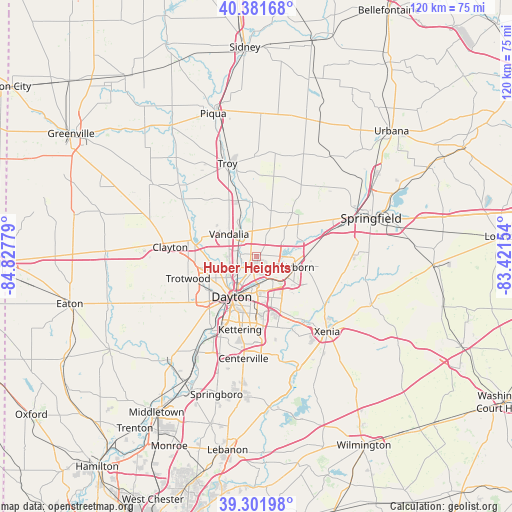
Huber Heights GPS coordinates[2]
39° 50' 38.22" North, 84° 7' 28.776" West
| Map corner | latitude | longitude |
|---|---|---|
| Upper-left | 40.38168°, | -84.82779° |
| Center: | 39.84395°, | -84.12466° |
| Lower-right: | 39.30198°, | -83.42154° |
| Map W x H: | 120.1×120.1 km | = 74.6×74.6mi |
| max Lat: | 71.29058° ⇑48.1% North |
| Huber Heights: | 39.84395° |
| min Lat: | ⇓51.9% South 19.06759° |
| min Long | Huber Heights | max Long |
| -171.73463° | -84.12466° | -66.98998° |
| W 58.9%⇐ | ⇒41.1% E |
Elevation
Elevation of Huber Heights is 284 m = 932 ft, and this is 10.8 m = 35 ft below average elevation for this country.
| Max E: |
3189 m = 10463 ft | 30.3% |
| Avg. | 294.8 m = 967 ft | |
| Huber Heights | 284 m = 932 ft | |
Min E: |
-60 m = -197 ft | 69.7% |
See also: United States elevation on elevation.city.
Geographical zone
Huber Heights is located in North temperate zone (between Tropic of Cancer and the Arctic Circle). Distance of this Northern Tropic circle is 1824.3 km =1133.6 mi to South.| Distance of | km | miles | from Huber Heights |
|---|---|---|---|
| North Pole | 5576.8 | 3465.3 | to North |
| Arctic Circle | 2970.9 | 1846 | to North |
| Tropic Cancer | 1824.3 | 1133.6 | to South |
| Equator | 4430.2 | 2752.8 | to South |


Nearby cities:
15 places around Huber Heights: (largest is in red/bold)
• Belmont
12.8 km =8 mi,  185°
185°
• Crystal Lakes
9.8 km =6.1 mi,  58°
58°
• Dayton
11 km =6.8 mi,  211°
211°
• Fairborn
9.3 km =5.8 mi,  105°
105°
• Fort McKinley
12.2 km =7.6 mi,  244°
244°
• Holiday Valley
13.4 km =8.3 mi,  84°
84°
• New Carlisle
13.3 km =8.3 mi,  39°
39°
• Northridge
7.4 km =4.6 mi, 236°
• Oakwood
13.8 km =8.6 mi,  197°
197°
• Park Layne
8.7 km =5.4 mi, 56°
• Riverside
7.1 km =4.4 mi,  179°
179°
• Shiloh
9.3 km =5.8 mi,  252°
252°
• Tipp City
13.4 km =8.3 mi,  342°
342°
• Vandalia
8.2 km =5.1 mi,  309°
309°
• Wright-Patterson AFB
6.8 km =4.2 mi,  122°
122°
Sources, notices
• [Note1] Compared only with cities in United States existing in our database
• [Src1] Map data: © OpenStreetMap contributors (CC-BY-SA)
• [Src2] Other city data from geonames.org with taken over terms of usage.
• [Src3] Geographical zone / Annual Mean Temperature by Robert A. Rohde @ Wikipedia
