Tipp City geodata
Tipp City (Ohio) is a populated place; located in United States in America/New_York (GMT-4) time zone. With population of 9,899 people, there are 4491 cities with bigger population in this country. Compared to other cities in United States, 53.2% of cities are located further ↓South; 58.7% of cities are located further ←West and 62.8% of cities have lower elevation than Tipp City. Note1


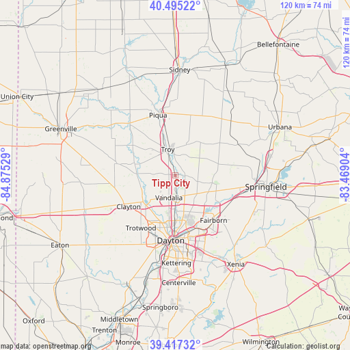
Tipp City GPS coordinates[2]
39° 57' 30.204" North, 84° 10' 19.776" West
| Map corner | latitude | longitude |
|---|---|---|
| Upper-left | 40.49522°, | -84.87529° |
| Center: | 39.95839°, | -84.17216° |
| Lower-right: | 39.41732°, | -83.46904° |
| Map W x H: | 119.9×119.9 km | = 74.5×74.5mi |
| max Lat: | 71.29058° ⇑46.8% North |
| Tipp City: | 39.95839° |
| min Lat: | ⇓53.2% South 19.06759° |
| min Long | Tipp City | max Long |
| -171.73463° | -84.17216° | -66.98998° |
| W 58.7%⇐ | ⇒41.3% E |
Elevation
Elevation of Tipp City is 252 m = 827 ft, and this is 42.8 m = 140 ft below average elevation for this country.
| Max E: |
3189 m = 10463 ft | 37.2% |
| Avg. | 294.8 m = 967 ft | |
| Tipp City | 252 m = 827 ft | |
Min E: |
-60 m = -197 ft | 62.8% |
See also: United States elevation on elevation.city.
Geographical zone
Tipp City is located in North temperate zone (between Tropic of Cancer and the Arctic Circle). Distance of this Northern Tropic circle is 1837 km =1141.5 mi to South.| Distance of | km | miles | from Tipp City |
|---|---|---|---|
| North Pole | 5564.1 | 3457.4 | to North |
| Arctic Circle | 2958.2 | 1838.1 | to North |
| Tropic Cancer | 1837 | 1141.5 | to South |
| Equator | 4443 | 2760.8 | to South |


Nearby cities:
15 places around Tipp City: (largest is in red/bold)
• Christiansburg
16.5 km =10.3 mi,  49°
49°
• Crystal Lakes
14.6 km =9.1 mi,  121°
121°
• Englewood
14.3 km =8.9 mi,  230°
230°
• Fort McKinley
19.2 km =11.9 mi,  201°
201°
• Huber Heights
13.4 km =8.3 mi,  162°
162°
• New Carlisle
12.7 km =7.9 mi,  101°
101°
• Northridge
16.9 km =10.5 mi,  187°
187°
• Park Layne
13.8 km =8.6 mi,  125°
125°
• Pleasant Hill
18 km =11.2 mi,  305°
305°
• Shiloh
16.3 km =10.1 mi, 197°
• Troy
9.4 km =5.8 mi,  343°
343°
• Union
13.3 km =8.3 mi,  239°
239°
• Vandalia
7.9 km =4.9 mi, 196°
• West Milton
13.3 km =8.3 mi,  271°
271°
• Wright-Patterson AFB
19.1 km =11.9 mi,  149°
149°
Sources, notices
• [Note1] Compared only with cities in United States existing in our database
• [Src1] Map data: © OpenStreetMap contributors (CC-BY-SA)
• [Src2] Other city data from geonames.org with taken over terms of usage.
• [Src3] Geographical zone / Annual Mean Temperature by Robert A. Rohde @ Wikipedia
