Dayton geodata
Dayton (Ohio) is a seat of a second-order administrative division; located in United States in America/New_York (GMT-4) time zone. With population of 140,599 people, there are 214 cities with bigger population in this country. Compared to other cities in United States, 51.2% of cities are located further ↓South; 58.7% of cities are located further ←West and 59.4% of cities have lower elevation than Dayton. Note1


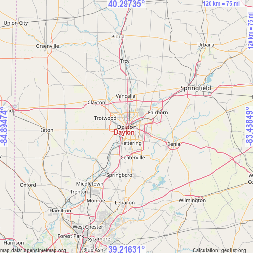
Dayton GPS coordinates[2]
39° 45' 32.22" North, 84° 11' 29.796" West
| Map corner | latitude | longitude |
|---|---|---|
| Upper-left | 40.29735°, | -84.89474° |
| Center: | 39.75895°, | -84.19161° |
| Lower-right: | 39.21631°, | -83.48849° |
| Map W x H: | 120.2×120.2 km | = 74.7×74.7mi |
| max Lat: | 71.29058° ⇑48.8% North |
| Dayton: | 39.75895° |
| min Lat: | ⇓51.2% South 19.06759° |
| min Long | Dayton | max Long |
| -171.73463° | -84.19161° | -66.98998° |
| W 58.7%⇐ | ⇒41.3% E |
Elevation
Elevation of Dayton is 237 m = 778 ft, and this is 57.8 m = 190 ft below average elevation for this country.
| Max E: |
3189 m = 10463 ft | 40.6% |
| Avg. | 294.8 m = 967 ft | |
| Dayton | 237 m = 778 ft | |
Min E: |
-60 m = -197 ft | 59.4% |
See also: Dayton elevation on elevation.city.
Geographical zone
Dayton is located in North temperate zone (between Tropic of Cancer and the Arctic Circle). Distance of this Northern Tropic circle is 1814.9 km =1127.7 mi to South.| Distance of | km | miles | from Dayton |
|---|---|---|---|
| North Pole | 5586.3 | 3471.2 | to North |
| Arctic Circle | 2980.4 | 1851.9 | to North |
| Tropic Cancer | 1814.9 | 1127.7 | to South |
| Equator | 4420.8 | 2747 | to South |


Nearby cities:
15 places around Dayton: (largest is in red/bold)
• Beavercreek
12.3 km =7.6 mi,  116°
116°
• Belmont
5.5 km =3.4 mi,  126°
126°
• Drexel
8.2 km =5.1 mi,  260°
260°
• Fort McKinley
6.8 km =4.2 mi,  309°
309°
• Huber Heights
11 km =6.8 mi,  31°
31°
• Kettering
8 km =5 mi,  165°
165°
• Moraine
6.3 km =3.9 mi,  202°
202°
• Northridge
5.4 km =3.4 mi,  355°
355°
• Oakwood
4 km =2.5 mi,  158°
158°
• Riverside
6.2 km =3.9 mi,  68°
68°
• Shiloh
7.4 km =4.6 mi,  334°
334°
• Trotwood
11.1 km =6.9 mi,  292°
292°
• Vandalia
14.7 km =9.1 mi, 357°
• West Carrollton City
10.9 km =6.8 mi,  208°
208°
• Wright-Patterson AFB
12.9 km =8 mi,  63°
63°
Sources, notices
• [Note1] Compared only with cities in United States existing in our database
• [Src1] Map data: © OpenStreetMap contributors (CC-BY-SA)
• [Src2] Other city data from geonames.org with taken over terms of usage.
• [Src3] Geographical zone / Annual Mean Temperature by Robert A. Rohde @ Wikipedia
