Jamestown geodata
Jamestown (Ohio) is a populated place; located in United States in America/New_York (GMT-4) time zone. With population of 2,027 people, there are 11872 cities with bigger population in this country. Compared to other cities in United States, 50.4% of cities are located further ↓South; 60% of cities are located further ←West and 76.4% of cities have lower elevation than Jamestown. Note1


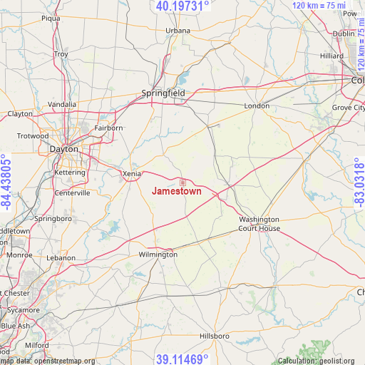
Jamestown GPS coordinates[2]
39° 39' 29.232" North, 83° 44' 5.712" West
| Map corner | latitude | longitude |
|---|---|---|
| Upper-left | 40.19731°, | -84.43805° |
| Center: | 39.65812°, | -83.73492° |
| Lower-right: | 39.11469°, | -83.0318° |
| Map W x H: | 120.4×120.4 km | = 74.8×74.8mi |
| max Lat: | 71.29058° ⇑49.6% North |
| Jamestown: | 39.65812° |
| min Lat: | ⇓50.4% South 19.06759° |
| min Long | Jamestown | max Long |
| -171.73463° | -83.73492° | -66.98998° |
| W 60%⇐ | ⇒40% E |
Elevation
Elevation of Jamestown is 323 m = 1060 ft, and this is 28.2 m = 93 ft above average elevation for this country.
| Max E: |
3189 m = 10463 ft | 23.6% |
| Jamestown | 323 m 1060 ft | |
| Avg. | 294.8 m = 967 ft | |
Min E: |
-60 m = -197 ft | 76.4% |
See also: United States elevation on elevation.city.
Geographical zone
Jamestown is located in North temperate zone (between Tropic of Cancer and the Arctic Circle). Distance of this Northern Tropic circle is 1803.7 km =1120.8 mi to South.| Distance of | km | miles | from Jamestown |
|---|---|---|---|
| North Pole | 5597.5 | 3478.1 | to North |
| Arctic Circle | 2991.6 | 1858.9 | to North |
| Tropic Cancer | 1803.7 | 1120.8 | to South |
| Equator | 4409.6 | 2740 | to South |


Nearby cities:
15 places around Jamestown: (largest is in red/bold)
• Beavercreek
28.7 km =17.8 mi,  281°
281°
• Bellbrook
28.9 km =18 mi,  265°
265°
• Cedarville
11.5 km =7.1 mi,  326°
326°
• Green Meadows
29.5 km =18.3 mi,  322°
322°
• Harveysburg
29.2 km =18.1 mi,  233°
233°
• Jeffersonville
14.7 km =9.1 mi,  91°
91°
• Lisbon
24.1 km =15 mi,  20°
20°
• Sabina
20.6 km =12.8 mi,  155°
155°
• Shawnee Hills
4.5 km =2.8 mi,  262°
262°
• South Charleston
20.5 km =12.7 mi, 24°
• Washington Court House
28.7 km =17.8 mi,  118°
118°
• Wilberforce
13.8 km =8.6 mi,  297°
297°
• Wilmington
25 km =15.5 mi,  198°
198°
• Xenia
16.9 km =10.5 mi, 280°
• Yellow Springs
21 km =13 mi, 321°
Sources, notices
• [Note1] Compared only with cities in United States existing in our database
• [Src1] Map data: © OpenStreetMap contributors (CC-BY-SA)
• [Src2] Other city data from geonames.org with taken over terms of usage.
• [Src3] Geographical zone / Annual Mean Temperature by Robert A. Rohde @ Wikipedia
