South Charleston geodata
South Charleston (Ohio) is a populated place; located in United States in America/New_York (GMT-4) time zone. With population of 1,661 people, there are 13042 cities with bigger population in this country. Compared to other cities in United States, 51.8% of cities are located further ↓South; 60.3% of cities are located further ←West and 79.3% of cities have lower elevation than South Charleston. Note1


South Charleston GPS coordinates[2]
39° 49' 31.224" North, 83° 38' 3.732" West
| Map corner | latitude | longitude |
|---|---|---|
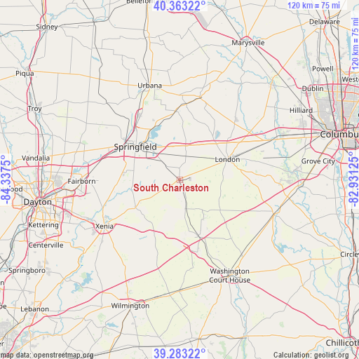
| Upper-left | 40.36322°, | -84.3375° |
| Center: | 39.82534°, | -83.63437° |
| Lower-right: | 39.28322°, | -82.93125° |
| Map W x H: | 120.1×120.1 km | = 74.6×74.6mi |
| max Lat: | 71.29058° ⇑48.2% North |
| South Charleston: | 39.82534° |
| min Lat: | ⇓51.8% South 19.06759° |
| min Long | South Charlesto | max Long |
| -171.73463° | -83.63437° | -66.98998° |
| W 60.3%⇐ | ⇒39.7% E |
Elevation
Elevation of South Charleston is 347 m = 1138 ft, and this is 52.2 m = 171 ft above average elevation for this country.
| Max E: |
3189 m = 10463 ft | 20.7% |
| South Charleston | 347 m 1138 ft | |
| Avg. | 294.8 m = 967 ft | |
Min E: |
-60 m = -197 ft | 79.3% |
See also: United States elevation on elevation.city.
Geographical zone
South Charleston is located in North temperate zone (between Tropic of Cancer and the Arctic Circle). Distance of this Northern Tropic circle is 1822.2 km =1132.3 mi to South.| Distance of | km | miles | from South Charleston |
|---|---|---|---|
| North Pole | 5578.9 | 3466.6 | to North |
| Arctic Circle | 2973 | 1847.3 | to North |
| Tropic Cancer | 1822.2 | 1132.3 | to South |
| Equator | 4428.2 | 2751.6 | to South |


Nearby cities:
15 places around South Charleston: (largest is in red/bold)
• Bethel
23.1 km =14.4 mi,  117°
117°
• Cedarville
17.4 km =10.8 mi,  238°
238°
• Choctaw Lake
19.7 km =12.2 mi,  40°
40°
• Enon
26.5 km =16.5 mi,  282°
282°
• Green Meadows
26.9 km =16.7 mi, 280°
• Jamestown
20.5 km =12.7 mi,  204°
204°
• Jeffersonville
20 km =12.4 mi,  162°
162°
• Lisbon
4 km =2.5 mi,  358°
358°
• London
17.3 km =10.7 mi,  66°
66°
• Mechanicsburg
28.2 km =17.5 mi,  13°
13°
• Northridge
22.2 km =13.8 mi,  326°
326°
• Shawnee Hills
23.2 km =14.4 mi,  214°
214°
• Springfield
18.5 km =11.5 mi,  306°
306°
• Wilberforce
24.1 km =15 mi, 239°
• Yellow Springs
21.7 km =13.5 mi,  264°
264°
Sources, notices
• [Note1] Compared only with cities in United States existing in our database
• [Src1] Map data: © OpenStreetMap contributors (CC-BY-SA)
• [Src2] Other city data from geonames.org with taken over terms of usage.
• [Src3] Geographical zone / Annual Mean Temperature by Robert A. Rohde @ Wikipedia
