Jeffersonville geodata
Jeffersonville (Ohio) is a populated place; located in United States in America/New_York (GMT-4) time zone. With population of 1,192 people, there are 15165 cities with bigger population in this country. Compared to other cities in United States, 50.4% of cities are located further ↓South; 60.4% of cities are located further ←West and 75.7% of cities have lower elevation than Jeffersonville. Note1


Jeffersonville GPS coordinates[2]
39° 39' 13.212" North, 83° 33' 49.716" West
| Map corner | latitude | longitude |
|---|---|---|
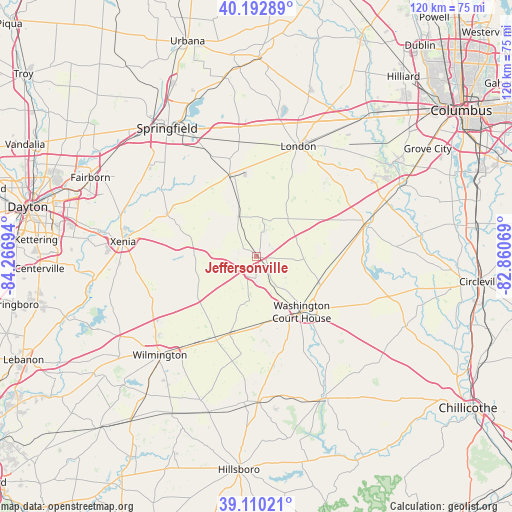
| Upper-left | 40.19289°, | -84.26694° |
| Center: | 39.65367°, | -83.56381° |
| Lower-right: | 39.11021°, | -82.86069° |
| Map W x H: | 120.4×120.4 km | = 74.8×74.8mi |
| max Lat: | 71.29058° ⇑49.6% North |
| Jeffersonville: | 39.65367° |
| min Lat: | ⇓50.4% South 19.06759° |
| min Long | Jeffersonville | max Long |
| -171.73463° | -83.56381° | -66.98998° |
| W 60.4%⇐ | ⇒39.6% E |
Elevation
Elevation of Jeffersonville is 318 m = 1043 ft, and this is 23.2 m = 76 ft above average elevation for this country.
| Max E: |
3189 m = 10463 ft | 24.3% |
| Jeffersonville | 318 m 1043 ft | |
| Avg. | 294.8 m = 967 ft | |
Min E: |
-60 m = -197 ft | 75.7% |
See also: United States elevation on elevation.city.
Geographical zone
Jeffersonville is located in North temperate zone (between Tropic of Cancer and the Arctic Circle). Distance of this Northern Tropic circle is 1803.2 km =1120.5 mi to South.| Distance of | km | miles | from Jeffersonville |
|---|---|---|---|
| North Pole | 5598 | 3478.4 | to North |
| Arctic Circle | 2992.1 | 1859.2 | to North |
| Tropic Cancer | 1803.2 | 1120.5 | to South |
| Equator | 4409.1 | 2739.7 | to South |


Nearby cities:
15 places around Jeffersonville: (largest is in red/bold)
• Bethel
16.9 km =10.5 mi,  59°
59°
• Bloomingburg
15.4 km =9.6 mi,  110°
110°
• Cedarville
23.2 km =14.4 mi,  295°
295°
• Jamestown
14.7 km =9.1 mi,  271°
271°
• Lisbon
23.8 km =14.8 mi,  345°
345°
• London
27.7 km =17.2 mi,  20°
20°
• Mount Sterling
26.6 km =16.5 mi,  74°
74°
• New Holland
28.5 km =17.7 mi, 112°
• Sabina
19.4 km =12.1 mi,  198°
198°
• Shawnee Hills
19.1 km =11.9 mi, 269°
• South Charleston
20 km =12.4 mi,  342°
342°
• Washington Court House
16.9 km =10.5 mi,  140°
140°
• Wilberforce
27.7 km =17.2 mi,  284°
284°
• Wilmington
32.4 km =20.1 mi,  224°
224°
• Xenia
31.5 km =19.6 mi, 276°
Sources, notices
• [Note1] Compared only with cities in United States existing in our database
• [Src1] Map data: © OpenStreetMap contributors (CC-BY-SA)
• [Src2] Other city data from geonames.org with taken over terms of usage.
• [Src3] Geographical zone / Annual Mean Temperature by Robert A. Rohde @ Wikipedia
