New Holland geodata
New Holland (Ohio) is a populated place; located in United States in America/New_York (GMT-4) time zone. With population of 836 people, there are 17486 cities with bigger population in this country. Compared to other cities in United States, 50.4% of cities are located further ↑North; 61.3% of cities are located further ←West and 64.3% of cities have lower elevation than New Holland. Note1


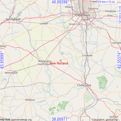
New Holland GPS coordinates[2]
39° 33' 14.22" North, 83° 15' 24.696" West
| Map corner | latitude | longitude |
|---|---|---|
| Upper-left | 40.09396°, | -83.95999° |
| Center: | 39.55395°, | -83.25686° |
| Lower-right: | 39.00971°, | -82.55374° |
| Map W x H: | 120.6×120.6 km | = 74.9×74.9mi |
| max Lat: | 71.29058° ⇑50.4% North |
| New Holland: | 39.55395° |
| min Lat: | ⇓49.6% South 19.06759° |
| min Long | New Holland | max Long |
| -171.73463° | -83.25686° | -66.98998° |
| W 61.3%⇐ | ⇒38.7% E |
Elevation
Elevation of New Holland is 259 m = 850 ft, and this is 35.8 m = 117 ft below average elevation for this country.
| Max E: |
3189 m = 10463 ft | 35.7% |
| Avg. | 294.8 m = 967 ft | |
| New Holland | 259 m = 850 ft | |
Min E: |
-60 m = -197 ft | 64.3% |
See also: United States elevation on elevation.city.
Geographical zone
New Holland is located in North temperate zone (between Tropic of Cancer and the Arctic Circle). Distance of this Northern Tropic circle is 1792.1 km =1113.6 mi to South.| Distance of | km | miles | from New Holland |
|---|---|---|---|
| North Pole | 5609.1 | 3485.3 | to North |
| Arctic Circle | 3003.2 | 1866.1 | to North |
| Tropic Cancer | 1792.1 | 1113.6 | to South |
| Equator | 4398 | 2732.8 | to South |


Nearby cities:
15 places around New Holland: (largest is in red/bold)
• Andersonville
25.4 km =15.8 mi,  123°
123°
• Bethel
22.8 km =14.2 mi,  329°
329°
• Bloomingburg
13.2 km =8.2 mi,  295°
295°
• Circleville
27.1 km =16.8 mi,  78°
78°
• Commercial Point
29.3 km =18.2 mi,  35°
35°
• Frankfort
18.2 km =11.3 mi,  158°
158°
• Greenfield
24.9 km =15.5 mi,  205°
205°
• Jeffersonville
28.5 km =17.7 mi,  292°
292°
• Kingston
31 km =19.3 mi,  106°
106°
• Logan Elm Village
26.2 km =16.3 mi,  86°
86°
• Mount Sterling
18.4 km =11.4 mi,  357°
357°
• North Fork Village
31.2 km =19.4 mi,  141°
141°
• South Bloomfield
29.5 km =18.3 mi,  51°
51°
• Washington Court House
15.7 km =9.8 mi,  262°
262°
• Williamsport
12.2 km =7.6 mi,  73°
73°
Sources, notices
• [Note1] Compared only with cities in United States existing in our database
• [Src1] Map data: © OpenStreetMap contributors (CC-BY-SA)
• [Src2] Other city data from geonames.org with taken over terms of usage.
• [Src3] Geographical zone / Annual Mean Temperature by Robert A. Rohde @ Wikipedia
