Pomeroy geodata
Pomeroy (Ohio) is a seat of a second-order administrative division; located in United States in America/New_York (GMT-4) time zone. With population of 1,821 people, there are 12470 cities with bigger population in this country. Compared to other cities in United States, 54.6% of cities are located further ↑North; 65.4% of cities are located further ←West and 54.5% of cities have higher elevation than Pomeroy. Note1


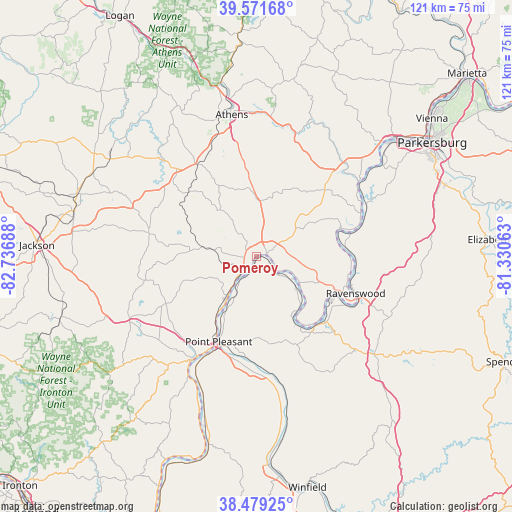
Pomeroy GPS coordinates[2]
39° 1' 39.288" North, 82° 2' 1.5" West
| Map corner | latitude | longitude |
|---|---|---|
| Upper-left | 39.57168°, | -82.73688° |
| Center: | 39.02758°, | -82.03375° |
| Lower-right: | 38.47925°, | -81.33063° |
| Map W x H: | 121.5×121.5 km | = 75.5×75.5mi |
| max Lat: | 71.29058° ⇑54.6% North |
| Pomeroy: | 39.02758° |
| min Lat: | ⇓45.4% South 19.06759° |
| min Long | Pomeroy | max Long |
| -171.73463° | -82.03375° | -66.98998° |
| W 65.4%⇐ | ⇒34.6% E |
Elevation
Elevation of Pomeroy is 182 m = 597 ft, and this is 112.8 m = 370 ft below average elevation for this country.
| Max E: |
3189 m = 10463 ft | 54.5% |
| Avg. | 294.8 m = 967 ft | |
| Pomeroy | 182 m = 597 ft | |
Min E: |
-60 m = -197 ft | 45.5% |
See also: United States elevation on elevation.city.
Geographical zone
Pomeroy is located in North temperate zone (between Tropic of Cancer and the Arctic Circle). Distance of this Northern Tropic circle is 1733.5 km =1077.1 mi to South.| Distance of | km | miles | from Pomeroy |
|---|---|---|---|
| North Pole | 5667.6 | 3521.7 | to North |
| Arctic Circle | 3061.7 | 1902.5 | to North |
| Tropic Cancer | 1733.5 | 1077.1 | to South |
| Equator | 4339.5 | 2696.4 | to South |


Nearby cities:
15 places around Pomeroy: (largest is in red/bold)
• Albany
26.6 km =16.5 mi,  326°
326°
• Athens
34 km =21.1 mi,  350°
350°
• Gallipolis
28.3 km =17.6 mi,  211°
211°
• Gallipolis Ferry
31.9 km =19.8 mi, 206°
• Hartford City
4.7 km =2.9 mi,  124°
124°
• Mason
0.8 km =0.5 mi,  147°
147°
• Middleport
3.2 km =2 mi,  204°
204°
• New Haven
6.9 km =4.3 mi,  131°
131°
• Point Pleasant
22.2 km =13.8 mi, 203°
• Racine
12.1 km =7.5 mi, 121°
• Ravenswood
25.2 km =15.7 mi,  110°
110°
• Rio Grande
34.2 km =21.3 mi,  241°
241°
• Ripley
36.3 km =22.6 mi, 129°
• Syracuse
6.1 km =3.8 mi, 122°
• The Plains
38.9 km =24.2 mi, 347°
Sources, notices
• [Note1] Compared only with cities in United States existing in our database
• [Src1] Map data: © OpenStreetMap contributors (CC-BY-SA)
• [Src2] Other city data from geonames.org with taken over terms of usage.
• [Src3] Geographical zone / Annual Mean Temperature by Robert A. Rohde @ Wikipedia
