Athens geodata
Athens (Ohio) is a seat of a second-order administrative division; located in United States in America/New_York (GMT-4) time zone. With population of 25,044 people, there are 1999 cities with bigger population in this country. Compared to other cities in United States, 52% of cities are located further ↑North; 65.2% of cities are located further ←West and 56.4% of cities have lower elevation than Athens. Note1


Athens GPS coordinates[2]
39° 19' 45.264" North, 82° 6' 4.536" West
| Map corner | latitude | longitude |
|---|---|---|
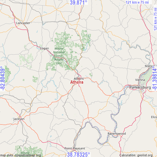
| Upper-left | 39.871°, | -82.80439° |
| Center: | 39.32924°, | -82.10126° |
| Lower-right: | 38.78325°, | -81.39814° |
| Map W x H: | 120.9×120.9 km | = 75.1×75.1mi |
| max Lat: | 71.29058° ⇑52% North |
| Athens: | 39.32924° |
| min Lat: | ⇓48% South 19.06759° |
| min Long | Athens | max Long |
| -171.73463° | -82.10126° | -66.98998° |
| W 65.2%⇐ | ⇒34.8% E |
Elevation
Elevation of Athens is 224 m = 735 ft, and this is 70.8 m = 232 ft below average elevation for this country.
| Max E: |
3189 m = 10463 ft | 43.6% |
| Avg. | 294.8 m = 967 ft | |
| Athens | 224 m = 735 ft | |
Min E: |
-60 m = -197 ft | 56.4% |
See also: United States elevation on elevation.city.
Geographical zone
Athens is located in North temperate zone (between Tropic of Cancer and the Arctic Circle). Distance of this Northern Tropic circle is 1767.1 km =1098 mi to South.| Distance of | km | miles | from Athens |
|---|---|---|---|
| North Pole | 5634.1 | 3500.9 | to North |
| Arctic Circle | 3028.2 | 1881.6 | to North |
| Tropic Cancer | 1767.1 | 1098 | to South |
| Equator | 4373 | 2717.3 | to South |


Nearby cities:
15 places around Athens: (largest is in red/bold)
• Albany
14.3 km =8.9 mi,  217°
217°
• Buchtel
16.3 km =10.1 mi,  334°
334°
• Chauncey
8 km =5 mi,  342°
342°
• Corning
30.4 km =18.9 mi,  2°
2°
• Glouster
19.4 km =12.1 mi, 4°
• Hartford City
37.4 km =23.2 mi,  165°
165°
• Logan
35.2 km =21.9 mi,  311°
311°
• Mason
34.8 km =21.6 mi, 169°
• McArthur
33.7 km =20.9 mi,  254°
254°
• Middleport
36.7 km =22.8 mi, 172°
• Nelsonville
18.2 km =11.3 mi,  322°
322°
• New Straitsville
30 km =18.6 mi, 337°
• Pomeroy
34 km =21.1 mi, 170°
• Shawnee
32.1 km =19.9 mi, 342°
• The Plains
5.2 km =3.2 mi, 328°
Sources, notices
• [Note1] Compared only with cities in United States existing in our database
• [Src1] Map data: © OpenStreetMap contributors (CC-BY-SA)
• [Src2] Other city data from geonames.org with taken over terms of usage.
• [Src3] Geographical zone / Annual Mean Temperature by Robert A. Rohde @ Wikipedia
