Albany geodata
Albany (Ohio) is a populated place; located in United States in America/New_York (GMT-4) time zone. With population of 905 people, there are 16946 cities with bigger population in this country. Compared to other cities in United States, 52.8% of cities are located further ↑North; 64.9% of cities are located further ←West and 58.6% of cities have lower elevation than Albany. Note1


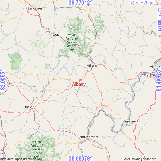
Albany GPS coordinates[2]
39° 13' 39.252" North, 82° 12' 8.532" West
| Map corner | latitude | longitude |
|---|---|---|
| Upper-left | 39.77012°, | -82.9055° |
| Center: | 39.22757°, | -82.20237° |
| Lower-right: | 38.68079°, | -81.49925° |
| Map W x H: | 121.1×121.1 km | = 75.2×75.2mi |
| max Lat: | 71.29058° ⇑52.8% North |
| Albany: | 39.22757° |
| min Lat: | ⇓47.2% South 19.06759° |
| min Long | Albany | max Long |
| -171.73463° | -82.20237° | -66.98998° |
| W 64.9%⇐ | ⇒35.1% E |
Elevation
Elevation of Albany is 233 m = 764 ft, and this is 61.8 m = 203 ft below average elevation for this country.
| Max E: |
3189 m = 10463 ft | 41.4% |
| Avg. | 294.8 m = 967 ft | |
| Albany | 233 m = 764 ft | |
Min E: |
-60 m = -197 ft | 58.6% |
See also: United States elevation on elevation.city.
Geographical zone
Albany is located in North temperate zone (between Tropic of Cancer and the Arctic Circle). Distance of this Northern Tropic circle is 1755.8 km =1091 mi to South.| Distance of | km | miles | from Albany |
|---|---|---|---|
| North Pole | 5645.4 | 3507.9 | to North |
| Arctic Circle | 3039.5 | 1888.7 | to North |
| Tropic Cancer | 1755.8 | 1091 | to South |
| Equator | 4361.7 | 2710.2 | to South |


Nearby cities:
15 places around Albany: (largest is in red/bold)
• Athens
14.3 km =8.9 mi,  37°
37°
• Buchtel
26.1 km =16.2 mi,  3°
3°
• Chauncey
19.9 km =12.4 mi,  18°
18°
• Glouster
32.3 km =20.1 mi, 18°
• Hamden
29 km =18 mi,  254°
254°
• Hartford City
30.9 km =19.2 mi,  143°
143°
• Mason
27.3 km =17 mi,  146°
146°
• McArthur
23.9 km =14.9 mi,  275°
275°
• Middleport
28.4 km =17.6 mi, 152°
• Nelsonville
25.8 km =16 mi,  354°
354°
• New Haven
33.3 km =20.7 mi, 143°
• Pomeroy
26.6 km =16.5 mi, 146°
• Syracuse
32.3 km =20.1 mi, 142°
• The Plains
16.8 km =10.4 mi, 20°
• Wellston
30.8 km =19.1 mi, 247°
Sources, notices
• [Note1] Compared only with cities in United States existing in our database
• [Src1] Map data: © OpenStreetMap contributors (CC-BY-SA)
• [Src2] Other city data from geonames.org with taken over terms of usage.
• [Src3] Geographical zone / Annual Mean Temperature by Robert A. Rohde @ Wikipedia
