Springfield geodata
Springfield (Ohio) is a seat of a second-order administrative division; located in United States in America/New_York (GMT-4) time zone. With population of 59,680 people, there are 755 cities with bigger population in this country. Compared to other cities in United States, 52.7% of cities are located further ↓South; 59.8% of cities are located further ←West and 73.6% of cities have lower elevation than Springfield. Note1


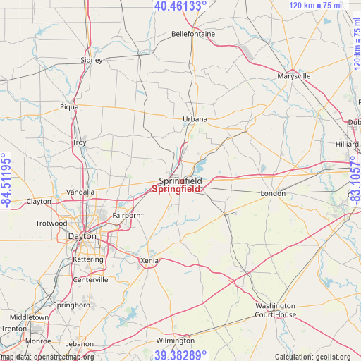
Springfield GPS coordinates[2]
39° 55' 27.228" North, 83° 48' 31.752" West
| Map corner | latitude | longitude |
|---|---|---|
| Upper-left | 40.46133°, | -84.51195° |
| Center: | 39.92423°, | -83.80882° |
| Lower-right: | 39.38289°, | -83.1057° |
| Map W x H: | 119.9×119.9 km | = 74.5×74.5mi |
| max Lat: | 71.29058° ⇑47.3% North |
| Springfield: | 39.92423° |
| min Lat: | ⇓52.7% South 19.06759° |
| min Long | Springfield | max Long |
| -171.73463° | -83.80882° | -66.98998° |
| W 59.8%⇐ | ⇒40.2% E |
Elevation
Elevation of Springfield is 305 m = 1001 ft, and this is 10.2 m = 33 ft above average elevation for this country.
| Max E: |
3189 m = 10463 ft | 26.4% |
| Springfield | 305 m 1001 ft | |
| Avg. | 294.8 m = 967 ft | |
Min E: |
-60 m = -197 ft | 73.6% |
See also: Springfield elevation on elevation.city.
Geographical zone
Springfield is located in North temperate zone (between Tropic of Cancer and the Arctic Circle). Distance of this Northern Tropic circle is 1833.2 km =1139.1 mi to South.| Distance of | km | miles | from Springfield |
|---|---|---|---|
| North Pole | 5567.9 | 3459.7 | to North |
| Arctic Circle | 2962 | 1840.5 | to North |
| Tropic Cancer | 1833.2 | 1139.1 | to South |
| Equator | 4439.2 | 2758.4 | to South |


Nearby cities:
15 places around Springfield: (largest is in red/bold)
• Cedarville
20 km =12.4 mi,  179°
179°
• Christiansburg
23.6 km =14.7 mi,  308°
308°
• Crystal Lakes
19 km =11.8 mi,  258°
258°
• Enon
12.1 km =7.5 mi,  244°
244°
• Fairborn
21.3 km =13.2 mi, 237°
• Green Meadows
13.1 km =8.1 mi, 242°
• Holiday Valley
15.6 km =9.7 mi, 240°
• Lisbon
16.4 km =10.2 mi,  115°
115°
• New Carlisle
18.5 km =11.5 mi,  274°
274°
• Northridge
7.9 km =4.9 mi,  18°
18°
• Park Layne
20.1 km =12.5 mi, 257°
• South Charleston
18.5 km =11.5 mi,  126°
126°
• Urbana
21 km =13 mi,  13°
13°
• Wilberforce
23.9 km =14.9 mi,  194°
194°
• Yellow Springs
14.7 km =9.1 mi,  206°
206°
Sources, notices
• [Note1] Compared only with cities in United States existing in our database
• [Src1] Map data: © OpenStreetMap contributors (CC-BY-SA)
• [Src2] Other city data from geonames.org with taken over terms of usage.
• [Src3] Geographical zone / Annual Mean Temperature by Robert A. Rohde @ Wikipedia
