Christiansburg geodata
Christiansburg (Ohio) is a populated place; located in United States in America/New_York (GMT-4) time zone. With population of 504 people, there are 20845 cities with bigger population in this country. Compared to other cities in United States, 54.1% of cities are located further ↓South; 59.2% of cities are located further ←West and 78.6% of cities have lower elevation than Christiansburg. Note1


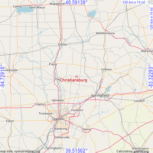
Christiansburg GPS coordinates[2]
40° 3' 19.188" North, 84° 1' 33.78" West
| Map corner | latitude | longitude |
|---|---|---|
| Upper-left | 40.59139°, | -84.72918° |
| Center: | 40.05533°, | -84.02605° |
| Lower-right: | 39.51502°, | -83.32293° |
| Map W x H: | 119.7×119.7 km | = 74.4×74.4mi |
| max Lat: | 71.29058° ⇑45.9% North |
| Christiansburg: | 40.05533° |
| min Lat: | ⇓54.1% South 19.06759° |
| min Long | Christiansburg | max Long |
| -171.73463° | -84.02605° | -66.98998° |
| W 59.2%⇐ | ⇒40.8% E |
Elevation
Elevation of Christiansburg is 341 m = 1119 ft, and this is 46.2 m = 152 ft above average elevation for this country.
| Max E: |
3189 m = 10463 ft | 21.4% |
| Christiansburg | 341 m 1119 ft | |
| Avg. | 294.8 m = 967 ft | |
Min E: |
-60 m = -197 ft | 78.6% |
See also: United States elevation on elevation.city.
Geographical zone
Christiansburg is located in North temperate zone (between Tropic of Cancer and the Arctic Circle). Distance of this Northern Tropic circle is 1847.8 km =1148.2 mi to South.| Distance of | km | miles | from Christiansburg |
|---|---|---|---|
| North Pole | 5553.3 | 3450.7 | to North |
| Arctic Circle | 2947.4 | 1831.4 | to North |
| Tropic Cancer | 1847.8 | 1148.2 | to South |
| Equator | 4453.7 | 2767.4 | to South |


Nearby cities:
15 places around Christiansburg: (largest is in red/bold)
• Crystal Lakes
18.5 km =11.5 mi,  180°
180°
• Enon
21.1 km =13.1 mi,  158°
158°
• Green Meadows
21.9 km =13.6 mi, 161°
• Holiday Valley
22.7 km =14.1 mi,  167°
167°
• Huber Heights
25 km =15.5 mi,  199°
199°
• New Carlisle
13.2 km =8.2 mi, 179°
• Northridge
22.2 km =13.8 mi,  108°
108°
• Park Layne
18.8 km =11.7 mi, 183°
• Piqua
20.9 km =13 mi,  298°
298°
• Saint Paris
9.9 km =6.2 mi,  34°
34°
• Springfield
23.6 km =14.7 mi,  128°
128°
• Tipp City
16.5 km =10.3 mi,  229°
229°
• Troy
15.2 km =9.4 mi,  263°
263°
• Urbana
24 km =14.9 mi,  75°
75°
• Vandalia
23.5 km =14.6 mi,  218°
218°
Sources, notices
• [Note1] Compared only with cities in United States existing in our database
• [Src1] Map data: © OpenStreetMap contributors (CC-BY-SA)
• [Src2] Other city data from geonames.org with taken over terms of usage.
• [Src3] Geographical zone / Annual Mean Temperature by Robert A. Rohde @ Wikipedia
