Stoutsville geodata
Stoutsville (Ohio) is a populated place; located in United States in America/New_York (GMT-4) time zone. With population of 566 people, there are 20074 cities with bigger population in this country. Compared to other cities in United States, 50.1% of cities are located further ↑North; 62.5% of cities are located further ←West and 71.7% of cities have lower elevation than Stoutsville. Note1


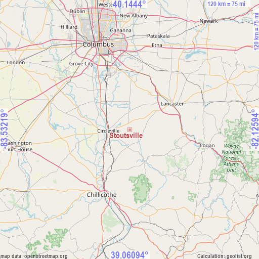
Stoutsville GPS coordinates[2]
39° 36' 17.244" North, 82° 49' 44.616" West
| Map corner | latitude | longitude |
|---|---|---|
| Upper-left | 40.1444°, | -83.53219° |
| Center: | 39.60479°, | -82.82906° |
| Lower-right: | 39.06094°, | -82.12594° |
| Map W x H: | 120.5×120.5 km | = 74.9×74.9mi |
| max Lat: | 71.29058° ⇑50.1% North |
| Stoutsville: | 39.60479° |
| min Lat: | ⇓49.9% South 19.06759° |
| min Long | Stoutsville | max Long |
| -171.73463° | -82.82906° | -66.98998° |
| W 62.5%⇐ | ⇒37.5% E |
Elevation
Elevation of Stoutsville is 294 m = 965 ft, and this is 0.80000000000001 m = 3 ft below average elevation for this country.
| Max E: |
3189 m = 10463 ft | 28.3% |
| Avg. | 294.8 m = 967 ft | |
| Stoutsville | 294 m = 965 ft | |
Min E: |
-60 m = -197 ft | 71.7% |
See also: United States elevation on elevation.city.
Geographical zone
Stoutsville is located in North temperate zone (between Tropic of Cancer and the Arctic Circle). Distance of this Northern Tropic circle is 1797.7 km =1117 mi to South.| Distance of | km | miles | from Stoutsville |
|---|---|---|---|
| North Pole | 5603.4 | 3481.8 | to North |
| Arctic Circle | 2997.5 | 1862.6 | to North |
| Tropic Cancer | 1797.7 | 1117 | to South |
| Equator | 4403.6 | 2736.3 | to South |


Nearby cities:
15 places around Stoutsville: (largest is in red/bold)
• Amanda
8.8 km =5.5 mi,  55°
55°
• Andersonville
25 km =15.5 mi,  218°
218°
• Ashville
16.3 km =10.1 mi,  319°
319°
• Canal Winchester
26.6 km =16.5 mi,  4°
4°
• Carroll
24.2 km =15 mi,  26°
26°
• Circleville
10 km =6.2 mi,  267°
267°
• Commercial Point
26.7 km =16.6 mi,  312°
312°
• Hide-A-Way Hills
30.6 km =19 mi,  79°
79°
• Kingston
16.1 km =10 mi,  205°
205°
• Lancaster
23.1 km =14.4 mi, 58°
• Laurelville
16.5 km =10.3 mi,  152°
152°
• Lithopolis
22.1 km =13.7 mi,  5°
5°
• Logan Elm Village
11.2 km =7 mi,  249°
249°
• South Bloomfield
18.5 km =11.5 mi, 313°
• Williamsport
25.1 km =15.6 mi, 265°
Sources, notices
• [Note1] Compared only with cities in United States existing in our database
• [Src1] Map data: © OpenStreetMap contributors (CC-BY-SA)
• [Src2] Other city data from geonames.org with taken over terms of usage.
• [Src3] Geographical zone / Annual Mean Temperature by Robert A. Rohde @ Wikipedia
