Urbancrest geodata
Urbancrest (Ohio) is a populated place; located in United States in America/New_York (GMT-4) time zone. With population of 1,033 people, there are 16065 cities with bigger population in this country. Compared to other cities in United States, 52.5% of cities are located further ↓South; 61.8% of cities are located further ←West and 63.7% of cities have lower elevation than Urbancrest. Note1


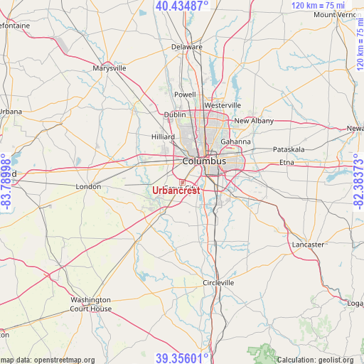
Urbancrest GPS coordinates[2]
39° 53' 51.216" North, 83° 5' 12.66" West
| Map corner | latitude | longitude |
|---|---|---|
| Upper-left | 40.43487°, | -83.78998° |
| Center: | 39.89756°, | -83.08685° |
| Lower-right: | 39.35601°, | -82.38373° |
| Map W x H: | 120×120 km | = 74.6×74.6mi |
| max Lat: | 71.29058° ⇑47.5% North |
| Urbancrest: | 39.89756° |
| min Lat: | ⇓52.5% South 19.06759° |
| min Long | Urbancrest | max Long |
| -171.73463° | -83.08685° | -66.98998° |
| W 61.8%⇐ | ⇒38.2% E |
Elevation
Elevation of Urbancrest is 256 m = 840 ft, and this is 38.8 m = 127 ft below average elevation for this country.
| Max E: |
3189 m = 10463 ft | 36.3% |
| Avg. | 294.8 m = 967 ft | |
| Urbancrest | 256 m = 840 ft | |
Min E: |
-60 m = -197 ft | 63.7% |
See also: United States elevation on elevation.city.
Geographical zone
Urbancrest is located in North temperate zone (between Tropic of Cancer and the Arctic Circle). Distance of this Northern Tropic circle is 1830.3 km =1137.3 mi to South.| Distance of | km | miles | from Urbancrest |
|---|---|---|---|
| North Pole | 5570.9 | 3461.6 | to North |
| Arctic Circle | 2965 | 1842.4 | to North |
| Tropic Cancer | 1830.3 | 1137.3 | to South |
| Equator | 4436.2 | 2756.5 | to South |


Nearby cities:
15 places around Urbancrest: (largest is in red/bold)
• Bexley
15 km =9.3 mi,  58°
58°
• Columbus
10.3 km =6.4 mi,  46°
46°
• Commercial Point
14.6 km =9.1 mi,  169°
169°
• Darbydale
9.5 km =5.9 mi,  239°
239°
• Grandview Heights
10 km =6.2 mi,  23°
23°
• Grove City
1.9 km =1.2 mi,  196°
196°
• Groveport
17.5 km =10.9 mi,  97°
97°
• Hilliard
16.3 km =10.1 mi,  338°
338°
• Lake Darby
13.8 km =8.6 mi,  298°
298°
• Lincoln Village
7.4 km =4.6 mi,  329°
329°
• Marble Cliff
10.1 km =6.3 mi,  12°
12°
• Obetz
11.8 km =7.3 mi, 100°
• Upper Arlington
11 km =6.8 mi, 10°
• Valley View
7.7 km =4.8 mi, 9°
• West Jefferson
16.4 km =10.2 mi,  288°
288°
Sources, notices
• [Note1] Compared only with cities in United States existing in our database
• [Src1] Map data: © OpenStreetMap contributors (CC-BY-SA)
• [Src2] Other city data from geonames.org with taken over terms of usage.
• [Src3] Geographical zone / Annual Mean Temperature by Robert A. Rohde @ Wikipedia
