Columbus geodata
Columbus (Ohio) is a seat of a first-order administrative division; located in United States in America/New_York (GMT-4) time zone. With population of 850,106 people, there are 17 cities with bigger population in this country. Compared to other cities in United States, 53.2% of cities are located further ↓South; 62% of cities are located further ←West and 60.5% of cities have lower elevation than Columbus. Note1


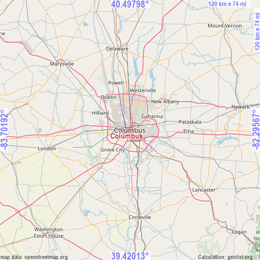
Columbus GPS coordinates[2]
39° 57' 40.248" North, 82° 59' 55.644" West
| Map corner | latitude | longitude |
|---|---|---|
| Upper-left | 40.49798°, | -83.70192° |
| Center: | 39.96118°, | -82.99879° |
| Lower-right: | 39.42013°, | -82.29567° |
| Map W x H: | 119.8×119.8 km | = 74.4×74.4mi |
| max Lat: | 71.29058° ⇑46.8% North |
| Columbus: | 39.96118° |
| min Lat: | ⇓53.2% South 19.06759° |
| min Long | Columbus | max Long |
| -171.73463° | -82.99879° | -66.98998° |
| W 62%⇐ | ⇒38% E |
Elevation
Elevation of Columbus is 242 m = 794 ft, and this is 52.8 m = 173 ft below average elevation for this country.
| Max E: |
3189 m = 10463 ft | 39.5% |
| Avg. | 294.8 m = 967 ft | |
| Columbus | 242 m = 794 ft | |
Min E: |
-60 m = -197 ft | 60.5% |
See also: Columbus elevation on elevation.city.
Geographical zone
Columbus is located in North temperate zone (between Tropic of Cancer and the Arctic Circle). Distance of this Northern Tropic circle is 1837.3 km =1141.6 mi to South.| Distance of | km | miles | from Columbus |
|---|---|---|---|
| North Pole | 5563.8 | 3457.2 | to North |
| Arctic Circle | 2957.9 | 1838 | to North |
| Tropic Cancer | 1837.3 | 1141.6 | to South |
| Equator | 4443.3 | 2760.9 | to South |


Nearby cities:
15 places around Columbus: (largest is in red/bold)
• Bexley
5.3 km =3.3 mi,  80°
80°
• Blacklick Estates
13.1 km =8.1 mi,  118°
118°
• Gahanna
12.1 km =7.5 mi,  57°
57°
• Grandview Heights
4.1 km =2.5 mi,  300°
300°
• Grove City
12 km =7.5 mi,  222°
222°
• Groveport
13.4 km =8.3 mi,  133°
133°
• Lincoln Village
11.3 km =7 mi,  266°
266°
• Marble Cliff
6.1 km =3.8 mi, 297°
• Minerva Park
13.6 km =8.5 mi,  20°
20°
• Obetz
10 km =6.2 mi,  155°
155°
• Riverlea
13.6 km =8.5 mi,  350°
350°
• Upper Arlington
6.6 km =4.1 mi, 304°
• Urbancrest
10.3 km =6.4 mi,  226°
226°
• Valley View
6.3 km =3.9 mi, 274°
• Whitehall
9.7 km =6 mi,  86°
86°
Sources, notices
• [Note1] Compared only with cities in United States existing in our database
• [Src1] Map data: © OpenStreetMap contributors (CC-BY-SA)
• [Src2] Other city data from geonames.org with taken over terms of usage.
• [Src3] Geographical zone / Annual Mean Temperature by Robert A. Rohde @ Wikipedia
