West Carrollton City geodata
West Carrollton City (Ohio) is a populated place; located in United States in America/New_York (GMT-4) time zone. With population of 13,297 people, there are 3598 cities with bigger population in this country. Compared to other cities in United States, 50.5% of cities are located further ↓South; 58.5% of cities are located further ←West and 55.1% of cities have lower elevation than West Carrollton City. Note1
Administrative division(s):
- Level 1: Ohio
- Level 2: Montgomery County
- Level 3: City of West Carrollton
Current local time in West Carrollton City:
03:52 AM, WednesdayDifference from your time zone: hours


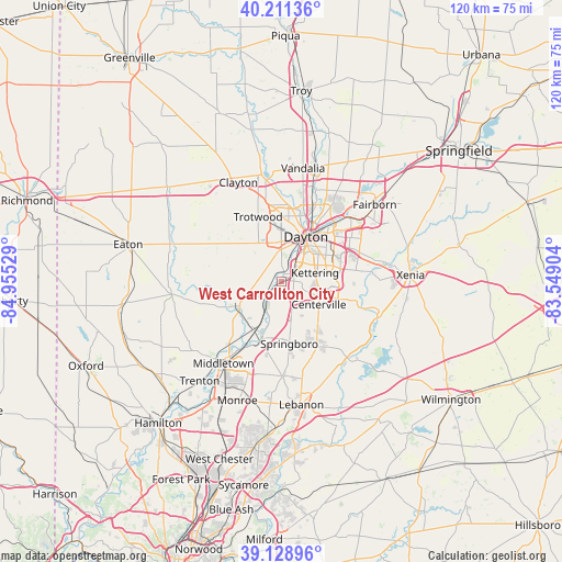
West Carrollton City GPS coordinates[2]
39° 40' 20.208" North, 84° 15' 7.776" West
| Map corner | latitude | longitude |
|---|---|---|
| Upper-left | 40.21136°, | -84.95529° |
| Center: | 39.67228°, | -84.25216° |
| Lower-right: | 39.12896°, | -83.54904° |
| Map W x H: | 120.4×120.4 km | = 74.8×74.8mi |
| max Lat: | 71.29058° ⇑49.5% North |
| West Carrollton City: | 39.67228° |
| min Lat: | ⇓50.5% South 19.06759° |
| min Long | West Carrollton | max Long |
| -171.73463° | -84.25216° | -66.98998° |
| W 58.5%⇐ | ⇒41.5% E |
Elevation
Elevation of West Carrollton City is 219 m = 719 ft, and this is 75.8 m = 249 ft below average elevation for this country.
| Max E: |
3189 m = 10463 ft | 44.9% |
| Avg. | 294.8 m = 967 ft | |
| West Carrollton City | 219 m = 719 ft | |
Min E: |
-60 m = -197 ft | 55.1% |
See also: United States elevation on elevation.city.
Geographical zone
West Carrollton City is located in North temperate zone (between Tropic of Cancer and the Arctic Circle). Distance of this Northern Tropic circle is 1805.2 km =1121.7 mi to South.| Distance of | km | miles | from West Carrollton City |
|---|---|---|---|
| North Pole | 5595.9 | 3477.1 | to North |
| Arctic Circle | 2990 | 1857.9 | to North |
| Tropic Cancer | 1805.2 | 1121.7 | to South |
| Equator | 4411.1 | 2740.9 | to South |


Nearby cities:
15 places around West Carrollton City: (largest is in red/bold)
• Belmont
11.5 km =7.1 mi,  56°
56°
• Carlisle
11.6 km =7.2 mi,  210°
210°
• Centerville
9.3 km =5.8 mi,  121°
121°
• Dayton
10.9 km =6.8 mi,  28°
28°
• Drexel
8.8 km =5.5 mi,  340°
340°
• Five Points
12.6 km =7.8 mi,  156°
156°
• Fort McKinley
13.9 km =8.6 mi,  359°
359°
• Franklin
13.4 km =8.3 mi,  199°
199°
• Germantown
11.3 km =7 mi,  242°
242°
• Kettering
7.4 km =4.6 mi,  74°
74°
• Miamisburg
4.4 km =2.7 mi,  222°
222°
• Moraine
4.7 km =2.9 mi,  36°
36°
• New Lebanon
14 km =8.7 mi,  305°
305°
• Oakwood
8.9 km =5.5 mi,  48°
48°
• Springboro
13.4 km =8.3 mi,  173°
173°
Sources, notices
• [Note1] Compared only with cities in United States existing in our database
• [Src1] Map data: © OpenStreetMap contributors (CC-BY-SA)
• [Src2] Other city data from geonames.org with taken over terms of usage.
• [Src3] Geographical zone / Annual Mean Temperature by Robert A. Rohde @ Wikipedia
