Bartlesville geodata
Bartlesville (Oklahoma) is a seat of a second-order administrative division; located in United States in America/Chicago (GMT-5) time zone. With population of 36,595 people, there are 1330 cities with bigger population in this country. Compared to other cities in United States, 67.1% of cities are located further ↑North; 73.4% of cities are located further →East and 54.7% of cities have lower elevation than Bartlesville. Note1


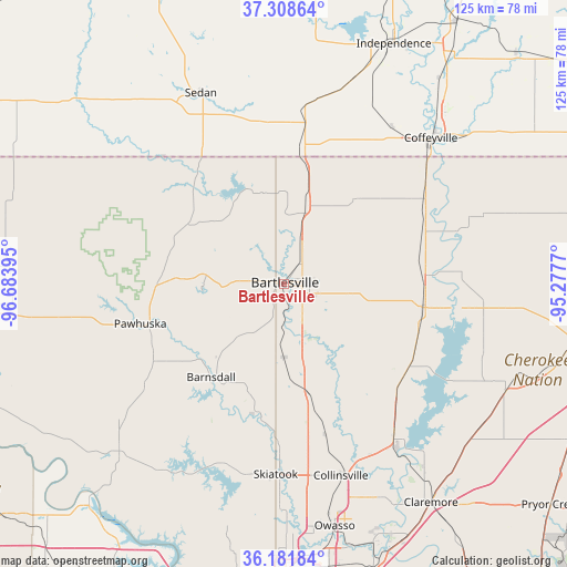
Bartlesville GPS coordinates[2]
36° 44' 50.316" North, 95° 58' 50.952" West
| Map corner | latitude | longitude |
|---|---|---|
| Upper-left | 37.30864°, | -96.68395° |
| Center: | 36.74731°, | -95.98082° |
| Lower-right: | 36.18184°, | -95.2777° |
| Map W x H: | 125.3×125.3 km | = 77.9×77.9mi |
| max Lat: | 71.29058° ⇑67.1% North |
| Bartlesville: | 36.74731° |
| min Lat: | ⇓32.9% South 19.06759° |
| min Long | Bartlesville | max Long |
| -171.73463° | -95.98082° | -66.98998° |
| W 26.6%⇐ | ⇒73.4% E |
Elevation
Elevation of Bartlesville is 217 m = 712 ft, and this is 77.8 m = 255 ft below average elevation for this country.
| Max E: |
3189 m = 10463 ft | 45.3% |
| Avg. | 294.8 m = 967 ft | |
| Bartlesville | 217 m = 712 ft | |
Min E: |
-60 m = -197 ft | 54.7% |
See also: United States elevation on elevation.city.
Geographical zone
Bartlesville is located in North temperate zone (between Tropic of Cancer and the Arctic Circle). Distance of this Northern Tropic circle is 1480 km =919.6 mi to South.| Distance of | km | miles | from Bartlesville |
|---|---|---|---|
| North Pole | 5921.1 | 3679.2 | to North |
| Arctic Circle | 3315.3 | 2060 | to North |
| Tropic Cancer | 1480 | 919.6 | to South |
| Equator | 4085.9 | 2538.9 | to South |


Nearby cities:
15 places around Bartlesville: (largest is in red/bold)
• Barnsdall
26.2 km =16.3 mi,  218°
218°
• Caney
29.6 km =18.4 mi,  7°
7°
• Coffeyville
45.7 km =28.4 mi,  45°
45°
• Collinsville
44.4 km =27.6 mi,  163°
163°
• Copan
17.4 km =10.8 mi,  16°
16°
• Dewey
6.7 km =4.2 mi,  36°
36°
• Limestone
52.2 km =32.4 mi, 156°
• Nowata
31 km =19.3 mi,  99°
99°
• Oologah
41.3 km =25.7 mi,  143°
143°
• Pawhuska
33 km =20.5 mi,  254°
254°
• Ramona
24.7 km =15.3 mi,  168°
168°
• Sedan
46 km =28.6 mi,  336°
336°
• Skiatook
42.2 km =26.2 mi,  182°
182°
• South Coffeyville
42.2 km =26.2 mi, 49°
• Sperry
50 km =31.1 mi, 181°
Sources, notices
• [Note1] Compared only with cities in United States existing in our database
• [Src1] Map data: © OpenStreetMap contributors (CC-BY-SA)
• [Src2] Other city data from geonames.org with taken over terms of usage.
• [Src3] Geographical zone / Annual Mean Temperature by Robert A. Rohde @ Wikipedia
