Barnsdall geodata
Barnsdall (Oklahoma) is a populated place; located in United States in America/Chicago (GMT-5) time zone. With population of 1,209 people, there are 15081 cities with bigger population in this country. Compared to other cities in United States, 67.9% of cities are located further ↑North; 73.8% of cities are located further →East and 57.9% of cities have lower elevation than Barnsdall. Note1


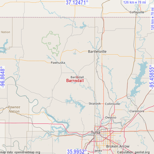
Barnsdall GPS coordinates[2]
36° 33' 43.272" North, 96° 9' 42.012" West
| Map corner | latitude | longitude |
|---|---|---|
| Upper-left | 37.12471°, | -96.8648° |
| Center: | 36.56202°, | -96.16167° |
| Lower-right: | 35.9952°, | -95.45855° |
| Map W x H: | 125.6×125.6 km | = 78×78mi |
| max Lat: | 71.29058° ⇑67.9% North |
| Barnsdall: | 36.56202° |
| min Lat: | ⇓32.1% South 19.06759° |
| min Long | Barnsdall | max Long |
| -171.73463° | -96.16167° | -66.98998° |
| W 26.2%⇐ | ⇒73.8% E |
Elevation
Elevation of Barnsdall is 230 m = 755 ft, and this is 64.8 m = 213 ft below average elevation for this country.
| Max E: |
3189 m = 10463 ft | 42.1% |
| Avg. | 294.8 m = 967 ft | |
| Barnsdall | 230 m = 755 ft | |
Min E: |
-60 m = -197 ft | 57.9% |
See also: United States elevation on elevation.city.
Geographical zone
Barnsdall is located in North temperate zone (between Tropic of Cancer and the Arctic Circle). Distance of this Northern Tropic circle is 1459.4 km =906.8 mi to South.| Distance of | km | miles | from Barnsdall |
|---|---|---|---|
| North Pole | 5941.7 | 3692 | to North |
| Arctic Circle | 3335.9 | 2072.8 | to North |
| Tropic Cancer | 1459.4 | 906.8 | to South |
| Equator | 4065.3 | 2526.1 | to South |


Nearby cities:
15 places around Barnsdall: (largest is in red/bold)
• Bartlesville
26.2 km =16.3 mi,  38°
38°
• Cleveland
39 km =24.2 mi,  224°
224°
• Collinsville
36.3 km =22.6 mi,  127°
127°
• Copan
42.8 km =26.6 mi,  29°
29°
• Dewey
32.9 km =20.4 mi, 37°
• Hominy
26.6 km =16.5 mi,  231°
231°
• Limestone
45.9 km =28.5 mi, 126°
• Oologah
42.5 km =26.4 mi,  107°
107°
• Owasso
42.6 km =26.5 mi,  139°
139°
• Pawhuska
19.6 km =12.2 mi,  306°
306°
• Ramona
21.6 km =13.4 mi,  99°
99°
• Sand Springs
47.2 km =29.3 mi,  174°
174°
• Skiatook
25.9 km =16.1 mi,  146°
146°
• Sperry
33.1 km =20.6 mi, 152°
• Turley
39.3 km =24.4 mi, 154°
Sources, notices
• [Note1] Compared only with cities in United States existing in our database
• [Src1] Map data: © OpenStreetMap contributors (CC-BY-SA)
• [Src2] Other city data from geonames.org with taken over terms of usage.
• [Src3] Geographical zone / Annual Mean Temperature by Robert A. Rohde @ Wikipedia
