Limestone geodata
Limestone (Oklahoma) is a populated place; located in United States in America/Chicago (GMT-5) time zone. With population of 629 people, there are 19367 cities with bigger population in this country. Compared to other cities in United States, 68.8% of cities are located further ↑North; 72.9% of cities are located further →East and 54.4% of cities have lower elevation than Limestone. Note1


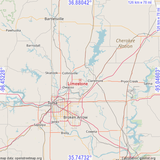
Limestone GPS coordinates[2]
36° 18' 57.348" North, 95° 44' 56.94" West
| Map corner | latitude | longitude |
|---|---|---|
| Upper-left | 36.88042°, | -96.45228° |
| Center: | 36.31593°, | -95.74915° |
| Lower-right: | 35.74732°, | -95.04603° |
| Map W x H: | 126×126 km | = 78.3×78.3mi |
| max Lat: | 71.29058° ⇑68.8% North |
| Limestone: | 36.31593° |
| min Lat: | ⇓31.2% South 19.06759° |
| min Long | Limestone | max Long |
| -171.73463° | -95.74915° | -66.98998° |
| W 27.1%⇐ | ⇒72.9% E |
Elevation
Elevation of Limestone is 216 m = 709 ft, and this is 78.8 m = 259 ft below average elevation for this country.
| Max E: |
3189 m = 10463 ft | 45.6% |
| Avg. | 294.8 m = 967 ft | |
| Limestone | 216 m = 709 ft | |
Min E: |
-60 m = -197 ft | 54.4% |
See also: United States elevation on elevation.city.
Geographical zone
Limestone is located in North temperate zone (between Tropic of Cancer and the Arctic Circle). Distance of this Northern Tropic circle is 1432 km =889.8 mi to South.| Distance of | km | miles | from Limestone |
|---|---|---|---|
| North Pole | 5969.1 | 3709 | to North |
| Arctic Circle | 3363.2 | 2089.8 | to North |
| Tropic Cancer | 1432 | 889.8 | to South |
| Equator | 4038 | 2509.1 | to South |


Nearby cities:
15 places around Limestone: (largest is in red/bold)
• Bushyhead
28 km =17.4 mi,  54°
54°
• Catoosa
14.1 km =8.8 mi,  178°
178°
• Claremore
11.9 km =7.4 mi,  91°
91°
• Collinsville
9.7 km =6 mi,  303°
303°
• Inola
28.2 km =17.5 mi,  130°
130°
• Justice
16.6 km =10.3 mi,  98°
98°
• New Tulsa
27.6 km =17.1 mi,  165°
165°
• Oologah
15 km =9.3 mi,  14°
14°
• Owasso
10.8 km =6.7 mi,  241°
241°
• Sequoyah
18 km =11.2 mi,  69°
69°
• Skiatook
23.3 km =14.5 mi,  284°
284°
• Sperry
21.8 km =13.5 mi,  264°
264°
• Tulsa
28.3 km =17.6 mi,  230°
230°
• Turley
21.9 km =13.6 mi,  247°
247°
• Verdigris
10.4 km =6.5 mi,  150°
150°
Sources, notices
• [Note1] Compared only with cities in United States existing in our database
• [Src1] Map data: © OpenStreetMap contributors (CC-BY-SA)
• [Src2] Other city data from geonames.org with taken over terms of usage.
• [Src3] Geographical zone / Annual Mean Temperature by Robert A. Rohde @ Wikipedia
