Gore geodata
Gore (Oklahoma) is a populated place; located in United States in America/Chicago (GMT-5) time zone. With population of 944 people, there are 16680 cities with bigger population in this country. Compared to other cities in United States, 72.5% of cities are located further ↑North; 71.4% of cities are located further →East and 59.9% of cities have higher elevation than Gore. Note1


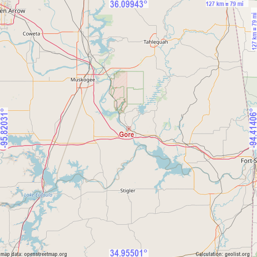
Gore GPS coordinates[2]
35° 31' 45.336" North, 95° 7' 1.848" West
| Map corner | latitude | longitude |
|---|---|---|
| Upper-left | 36.09943°, | -95.82031° |
| Center: | 35.52926°, | -95.11718° |
| Lower-right: | 34.95501°, | -94.41406° |
| Map W x H: | 127.2×127.2 km | = 79×79mi |
| max Lat: | 71.29058° ⇑72.5% North |
| Gore: | 35.52926° |
| min Lat: | ⇓27.5% South 19.06759° |
| min Long | Gore | max Long |
| -171.73463° | -95.11718° | -66.98998° |
| W 28.6%⇐ | ⇒71.4% E |
Elevation
Elevation of Gore is 155 m = 509 ft, and this is 139.8 m = 459 ft below average elevation for this country.
| Max E: |
3189 m = 10463 ft | 59.9% |
| Avg. | 294.8 m = 967 ft | |
| Gore | 155 m = 509 ft | |
Min E: |
-60 m = -197 ft | 40.1% |
See also: United States elevation on elevation.city.
Geographical zone
Gore is located in North temperate zone (between Tropic of Cancer and the Arctic Circle). Distance of this Northern Tropic circle is 1344.6 km =835.5 mi to South.| Distance of | km | miles | from Gore |
|---|---|---|---|
| North Pole | 6056.6 | 3763.4 | to North |
| Arctic Circle | 3450.7 | 2144.2 | to North |
| Tropic Cancer | 1344.6 | 835.5 | to South |
| Equator | 3950.5 | 2454.7 | to South |


Nearby cities:
15 places around Gore: (largest is in red/bold)
• Brent
34.4 km =21.4 mi,  121°
121°
• Carlisle
8.8 km =5.5 mi,  111°
111°
• Fort Gibson
32.2 km =20 mi,  338°
338°
• Keota
35.2 km =21.9 mi,  149°
149°
• Keys
32.8 km =20.4 mi,  24°
24°
• Muskogee
33.3 km =20.7 mi,  316°
316°
• Pettit
29.6 km =18.4 mi,  27°
27°
• Porum
23.5 km =14.6 mi,  214°
214°
• Sallisaw
30.8 km =19.1 mi,  104°
104°
• Stigler
30.6 km =19 mi,  180°
180°
• Texanna
35.3 km =21.9 mi,  235°
235°
• Vian
13.8 km =8.6 mi, 104°
• Warner
17.5 km =10.9 mi,  257°
257°
• Webbers Falls
2.3 km =1.4 mi, 209°
• Woodall
34.3 km =21.3 mi,  7°
7°
Sources, notices
• [Note1] Compared only with cities in United States existing in our database
• [Src1] Map data: © OpenStreetMap contributors (CC-BY-SA)
• [Src2] Other city data from geonames.org with taken over terms of usage.
• [Src3] Geographical zone / Annual Mean Temperature by Robert A. Rohde @ Wikipedia
