Sallisaw geodata
Sallisaw (Oklahoma) is a seat of a second-order administrative division; located in United States in America/Chicago (GMT-5) time zone. With population of 8,596 people, there are 4973 cities with bigger population in this country. Compared to other cities in United States, 72.9% of cities are located further ↑North; 70.6% of cities are located further →East and 58% of cities have higher elevation than Sallisaw. Note1


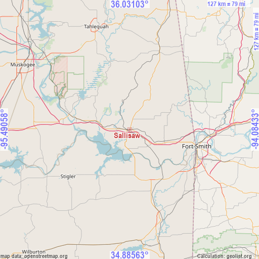
Sallisaw GPS coordinates[2]
35° 27' 37.332" North, 94° 47' 14.82" West
| Map corner | latitude | longitude |
|---|---|---|
| Upper-left | 36.03103°, | -95.49058° |
| Center: | 35.46037°, | -94.78745° |
| Lower-right: | 34.88563°, | -94.08433° |
| Map W x H: | 127.4×127.4 km | = 79.2×79.2mi |
| max Lat: | 71.29058° ⇑72.9% North |
| Sallisaw: | 35.46037° |
| min Lat: | ⇓27.1% South 19.06759° |
| min Long | Sallisaw | max Long |
| -171.73463° | -94.78745° | -66.98998° |
| W 29.4%⇐ | ⇒70.6% E |
Elevation
Elevation of Sallisaw is 165 m = 541 ft, and this is 129.8 m = 426 ft below average elevation for this country.
| Max E: |
3189 m = 10463 ft | 58% |
| Avg. | 294.8 m = 967 ft | |
| Sallisaw | 165 m = 541 ft | |
Min E: |
-60 m = -197 ft | 42% |
See also: United States elevation on elevation.city.
Geographical zone
Sallisaw is located in North temperate zone (between Tropic of Cancer and the Arctic Circle). Distance of this Northern Tropic circle is 1336.9 km =830.7 mi to South.| Distance of | km | miles | from Sallisaw |
|---|---|---|---|
| North Pole | 6064.2 | 3768.1 | to North |
| Arctic Circle | 3458.4 | 2148.9 | to North |
| Tropic Cancer | 1336.9 | 830.7 | to South |
| Equator | 3942.8 | 2449.9 | to South |


Nearby cities:
15 places around Sallisaw: (largest is in red/bold)
• Arkoma
34.1 km =21.2 mi,  110°
110°
• Bell
34.5 km =21.4 mi,  33°
33°
• Brent
10.3 km =6.4 mi,  183°
183°
• Brushy
12.1 km =7.5 mi, 27°
• Carlisle
22.1 km =13.7 mi,  281°
281°
• Cherry Tree
33.9 km =21.1 mi,  22°
22°
• Gore
30.8 km =19.1 mi, 284°
• Keota
25.8 km =16 mi,  208°
208°
• Muldrow
18.1 km =11.2 mi, 109°
• Panama
34.2 km =21.3 mi,  162°
162°
• Remy
22.9 km =14.2 mi,  91°
91°
• Roland
25.1 km =15.6 mi,  99°
99°
• Spiro
28.7 km =17.8 mi,  148°
148°
• Vian
17 km =10.6 mi, 284°
• Webbers Falls
31.5 km =19.6 mi, 280°
Sources, notices
• [Note1] Compared only with cities in United States existing in our database
• [Src1] Map data: © OpenStreetMap contributors (CC-BY-SA)
• [Src2] Other city data from geonames.org with taken over terms of usage.
• [Src3] Geographical zone / Annual Mean Temperature by Robert A. Rohde @ Wikipedia
