Inola geodata
Inola (Oklahoma) is a populated place; located in United States in America/Chicago (GMT-5) time zone. With population of 1,834 people, there are 12424 cities with bigger population in this country. Compared to other cities in United States, 69.6% of cities are located further ↑North; 72.4% of cities are located further →East and 52.8% of cities have higher elevation than Inola. Note1


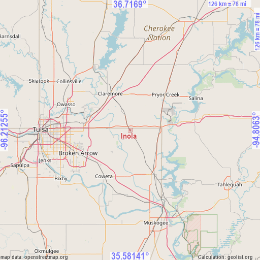
Inola GPS coordinates[2]
36° 9' 4.356" North, 95° 30' 33.912" West
| Map corner | latitude | longitude |
|---|---|---|
| Upper-left | 36.7169°, | -96.21255° |
| Center: | 36.15121°, | -95.50942° |
| Lower-right: | 35.58141°, | -94.8063° |
| Map W x H: | 126.3×126.3 km | = 78.5×78.5mi |
| max Lat: | 71.29058° ⇑69.6% North |
| Inola: | 36.15121° |
| min Lat: | ⇓30.4% South 19.06759° |
| min Long | Inola | max Long |
| -171.73463° | -95.50942° | -66.98998° |
| W 27.6%⇐ | ⇒72.4% E |
Elevation
Elevation of Inola is 188 m = 617 ft, and this is 106.8 m = 350 ft below average elevation for this country.
| Max E: |
3189 m = 10463 ft | 52.8% |
| Avg. | 294.8 m = 967 ft | |
| Inola | 188 m = 617 ft | |
Min E: |
-60 m = -197 ft | 47.2% |
See also: United States elevation on elevation.city.
Geographical zone
Inola is located in North temperate zone (between Tropic of Cancer and the Arctic Circle). Distance of this Northern Tropic circle is 1413.7 km =878.4 mi to South.| Distance of | km | miles | from Inola |
|---|---|---|---|
| North Pole | 5987.4 | 3720.4 | to North |
| Arctic Circle | 3381.5 | 2101.2 | to North |
| Tropic Cancer | 1413.7 | 878.4 | to South |
| Equator | 4019.6 | 2497.7 | to South |


Nearby cities:
15 places around Inola: (largest is in red/bold)
• Broken Arrow
27.6 km =17.1 mi,  246°
246°
• Catoosa
21.6 km =13.4 mi,  281°
281°
• Chouteau
15.4 km =9.6 mi,  75°
75°
• Claremore
20.3 km =12.6 mi,  331°
331°
• Coweta
25.6 km =15.9 mi,  209°
209°
• Justice
16.6 km =10.3 mi,  341°
341°
• Limestone
28.2 km =17.5 mi,  310°
310°
• Locust Grove
31.1 km =19.3 mi, 79°
• New Tulsa
16.9 km =10.5 mi,  240°
240°
• Porter
31.2 km =19.4 mi,  182°
182°
• Pryor
24.6 km =15.3 mi,  44°
44°
• Pryor Creek
24.5 km =15.2 mi, 44°
• Sequoyah
25.1 km =15.6 mi,  349°
349°
• Verdigris
18.8 km =11.7 mi,  299°
299°
• Wagoner
24.8 km =15.4 mi,  149°
149°
Sources, notices
• [Note1] Compared only with cities in United States existing in our database
• [Src1] Map data: © OpenStreetMap contributors (CC-BY-SA)
• [Src2] Other city data from geonames.org with taken over terms of usage.
• [Src3] Geographical zone / Annual Mean Temperature by Robert A. Rohde @ Wikipedia
