Mooreland geodata
Mooreland (Oklahoma) is a populated place; located in United States in America/Chicago (GMT-5) time zone. With population of 1,282 people, there are 14675 cities with bigger population in this country. Compared to other cities in United States, 68.3% of cities are located further ↑North; 80.1% of cities are located further →East and 89.4% of cities have lower elevation than Mooreland. Note1


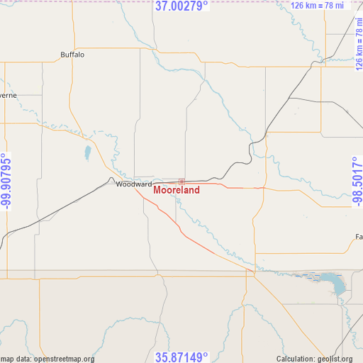
Mooreland GPS coordinates[2]
36° 26' 21.12" North, 99° 12' 17.352" West
| Map corner | latitude | longitude |
|---|---|---|
| Upper-left | 37.00279°, | -99.90795° |
| Center: | 36.4392°, | -99.20482° |
| Lower-right: | 35.87149°, | -98.5017° |
| Map W x H: | 125.8×125.8 km | = 78.2×78.2mi |
| max Lat: | 71.29058° ⇑68.3% North |
| Mooreland: | 36.4392° |
| min Lat: | ⇓31.7% South 19.06759° |
| min Long | Mooreland | max Long |
| -171.73463° | -99.20482° | -66.98998° |
| W 19.9%⇐ | ⇒80.1% E |
Elevation
Elevation of Mooreland is 587 m = 1926 ft, and this is 292.2 m = 959 ft above average elevation for this country.
| Max E: |
3189 m = 10463 ft | 10.6% |
| Mooreland | 587 m 1926 ft | |
| Avg. | 294.8 m = 967 ft | |
Min E: |
-60 m = -197 ft | 89.4% |
See also: United States elevation on elevation.city.
Geographical zone
Mooreland is located in North temperate zone (between Tropic of Cancer and the Arctic Circle). Distance of this Northern Tropic circle is 1445.7 km =898.3 mi to South.| Distance of | km | miles | from Mooreland |
|---|---|---|---|
| North Pole | 5955.4 | 3700.5 | to North |
| Arctic Circle | 3349.5 | 2081.3 | to North |
| Tropic Cancer | 1445.7 | 898.3 | to South |
| Equator | 4051.7 | 2517.6 | to South |


Nearby cities:
15 places around Mooreland: (largest is in red/bold)
• Alva
62.9 km =39.1 mi,  49°
49°
• Arnett
61.3 km =38.1 mi,  236°
236°
• Buffalo
58.2 km =36.2 mi,  319°
319°
• Canton
69.9 km =43.4 mi,  127°
127°
• Cherokee
83.4 km =51.8 mi,  65°
65°
• Fairview
67.6 km =42 mi,  106°
106°
• Helena
84.4 km =52.4 mi,  81°
81°
• Laverne
68.5 km =42.6 mi,  296°
296°
• Ringwood
86.1 km =53.5 mi,  94°
94°
• Seiling
41 km =25.5 mi,  142°
142°
• Shattuck
63.4 km =39.4 mi,  253°
253°
• Taloga
49.5 km =30.8 mi,  154°
154°
• Vici
33.3 km =20.7 mi,  194°
194°
• Waynoka
33.1 km =20.6 mi,  61°
61°
• Woodward
16.6 km =10.3 mi,  267°
267°
Sources, notices
• [Note1] Compared only with cities in United States existing in our database
• [Src1] Map data: © OpenStreetMap contributors (CC-BY-SA)
• [Src2] Other city data from geonames.org with taken over terms of usage.
• [Src3] Geographical zone / Annual Mean Temperature by Robert A. Rohde @ Wikipedia
