Alva geodata
Alva (Oklahoma) is a seat of a second-order administrative division; located in United States in America/Chicago (GMT-5) time zone. With population of 5,180 people, there are 7022 cities with bigger population in this country. Compared to other cities in United States, 66.9% of cities are located further ↑North; 79.6% of cities are located further →East and 84.8% of cities have lower elevation than Alva. Note1


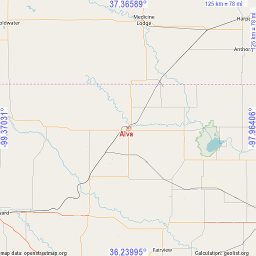
Alva GPS coordinates[2]
36° 48' 17.964" North, 98° 40' 1.848" West
| Map corner | latitude | longitude |
|---|---|---|
| Upper-left | 37.36589°, | -99.37031° |
| Center: | 36.80499°, | -98.66718° |
| Lower-right: | 36.23995°, | -97.96406° |
| Map W x H: | 125.2×125.2 km | = 77.8×77.8mi |
| max Lat: | 71.29058° ⇑66.9% North |
| Alva: | 36.80499° |
| min Lat: | ⇓33.1% South 19.06759° |
| min Long | Alva | max Long |
| -171.73463° | -98.66718° | -66.98998° |
| W 20.4%⇐ | ⇒79.6% E |
Elevation
Elevation of Alva is 419 m = 1375 ft, and this is 124.2 m = 407 ft above average elevation for this country.
| Max E: |
3189 m = 10463 ft | 15.2% |
| Alva | 419 m 1375 ft | |
| Avg. | 294.8 m = 967 ft | |
Min E: |
-60 m = -197 ft | 84.8% |
See also: United States elevation on elevation.city.
Geographical zone
Alva is located in North temperate zone (between Tropic of Cancer and the Arctic Circle). Distance of this Northern Tropic circle is 1486.4 km =923.6 mi to South.| Distance of | km | miles | from Alva |
|---|---|---|---|
| North Pole | 5914.7 | 3675.2 | to North |
| Arctic Circle | 3308.8 | 2056 | to North |
| Tropic Cancer | 1486.4 | 923.6 | to South |
| Equator | 4092.3 | 2542.8 | to South |


Nearby cities:
15 places around Alva: (largest is in red/bold)
• Anthony
68.5 km =42.6 mi,  55°
55°
• Attica
62.3 km =38.7 mi,  38°
38°
• Cherokee
28.2 km =17.5 mi,  101°
101°
• Coldwater
78 km =48.5 mi,  311°
311°
• Fairview
61.9 km =38.5 mi,  164°
164°
• Harper
78.2 km =48.6 mi,  46°
46°
• Helena
45.6 km =28.3 mi,  129°
129°
• Kiowa
28.6 km =17.8 mi,  34°
34°
• Lahoma
69.4 km =43.1 mi, 132°
• Medicine Lodge
53.5 km =33.2 mi,  8°
8°
• Mooreland
62.9 km =39.1 mi,  229°
229°
• Ringwood
60.5 km =37.6 mi,  141°
141°
• Seiling
76.6 km =47.6 mi,  197°
197°
• Waynoka
31.2 km =19.4 mi,  217°
217°
• Woodward
76.6 km =47.6 mi,  237°
237°
Sources, notices
• [Note1] Compared only with cities in United States existing in our database
• [Src1] Map data: © OpenStreetMap contributors (CC-BY-SA)
• [Src2] Other city data from geonames.org with taken over terms of usage.
• [Src3] Geographical zone / Annual Mean Temperature by Robert A. Rohde @ Wikipedia
