Mountain View geodata
Mountain View (Oklahoma) is a populated place; located in United States in America/Chicago (GMT-5) time zone. With population of 769 people, there are 18057 cities with bigger population in this country. Compared to other cities in United States, 74.8% of cities are located further ↑North; 79.7% of cities are located further →East and 84.3% of cities have lower elevation than Mountain View. Note1


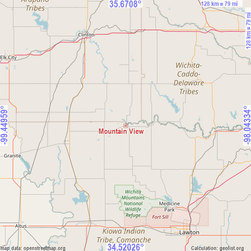
Mountain View GPS coordinates[2]
35° 5' 51.216" North, 98° 44' 47.256" West
| Map corner | latitude | longitude |
|---|---|---|
| Upper-left | 35.6708°, | -99.44959° |
| Center: | 35.09756°, | -98.74646° |
| Lower-right: | 34.52026°, | -98.04334° |
| Map W x H: | 127.9×127.9 km | = 79.5×79.5mi |
| max Lat: | 71.29058° ⇑74.8% North |
| Mountain View: | 35.09756° |
| min Lat: | ⇓25.2% South 19.06759° |
| min Long | Mountain View | max Long |
| -171.73463° | -98.74646° | -66.98998° |
| W 20.3%⇐ | ⇒79.7% E |
Elevation
Elevation of Mountain View is 411 m = 1348 ft, and this is 116.2 m = 381 ft above average elevation for this country.
| Max E: |
3189 m = 10463 ft | 15.7% |
| Mountain View | 411 m 1348 ft | |
| Avg. | 294.8 m = 967 ft | |
Min E: |
-60 m = -197 ft | 84.3% |
See also: United States elevation on elevation.city.
Geographical zone
Mountain View is located in North temperate zone (between Tropic of Cancer and the Arctic Circle). Distance of this Northern Tropic circle is 1296.6 km =805.7 mi to South.| Distance of | km | miles | from Mountain View |
|---|---|---|---|
| North Pole | 6104.6 | 3793.2 | to North |
| Arctic Circle | 3498.7 | 2174 | to North |
| Tropic Cancer | 1296.6 | 805.7 | to South |
| Equator | 3902.5 | 2424.9 | to South |


Nearby cities:
15 places around Mountain View: (largest is in red/bold)
• Anadarko
45.8 km =28.5 mi,  93°
93°
• Apache
41.4 km =25.7 mi,  123°
123°
• Binger
43.6 km =27.1 mi,  57°
57°
• Burns Flat
47.6 km =29.6 mi,  305°
305°
• Carnegie
13 km =8.1 mi, 87°
• Clinton
50.6 km =31.4 mi,  336°
336°
• Cordell
30.7 km =19.1 mi, 314°
• Corn
31.4 km =19.5 mi,  354°
354°
• Dill City
40.5 km =25.2 mi,  299°
299°
• Fort Cobb
28.3 km =17.6 mi, 89°
• Hobart
32.4 km =20.1 mi,  256°
256°
• Hydro
52.5 km =32.6 mi,  16°
16°
• Sentinel
39.6 km =24.6 mi,  279°
279°
• Snyder
52.2 km =32.4 mi,  201°
201°
• Weatherford
47.8 km =29.7 mi,  4°
4°
Sources, notices
• [Note1] Compared only with cities in United States existing in our database
• [Src1] Map data: © OpenStreetMap contributors (CC-BY-SA)
• [Src2] Other city data from geonames.org with taken over terms of usage.
• [Src3] Geographical zone / Annual Mean Temperature by Robert A. Rohde @ Wikipedia
