Hobart geodata
Hobart (Oklahoma) is a seat of a second-order administrative division; located in United States in America/Chicago (GMT-5) time zone. With population of 3,621 people, there are 8696 cities with bigger population in this country. Compared to other cities in United States, 75.3% of cities are located further ↑North; 80% of cities are located further →East and 87.3% of cities have lower elevation than Hobart. Note1


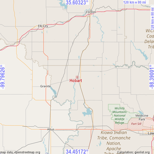
Hobart GPS coordinates[2]
35° 1' 46.2" North, 99° 5' 35.268" West
| Map corner | latitude | longitude |
|---|---|---|
| Upper-left | 35.60323°, | -99.79626° |
| Center: | 35.0295°, | -99.09313° |
| Lower-right: | 34.45172°, | -98.39001° |
| Map W x H: | 128×128 km | = 79.5×79.5mi |
| max Lat: | 71.29058° ⇑75.3% North |
| Hobart: | 35.0295° |
| min Lat: | ⇓24.7% South 19.06759° |
| min Long | Hobart | max Long |
| -171.73463° | -99.09313° | -66.98998° |
| W 20%⇐ | ⇒80% E |
Elevation
Elevation of Hobart is 477 m = 1565 ft, and this is 182.2 m = 598 ft above average elevation for this country.
| Max E: |
3189 m = 10463 ft | 12.7% |
| Hobart | 477 m 1565 ft | |
| Avg. | 294.8 m = 967 ft | |
Min E: |
-60 m = -197 ft | 87.3% |
See also: United States elevation on elevation.city.
Geographical zone
Hobart is located in North temperate zone (between Tropic of Cancer and the Arctic Circle). Distance of this Northern Tropic circle is 1289 km =800.9 mi to South.| Distance of | km | miles | from Hobart |
|---|---|---|---|
| North Pole | 6112.1 | 3797.9 | to North |
| Arctic Circle | 3506.3 | 2178.7 | to North |
| Tropic Cancer | 1289 | 800.9 | to South |
| Equator | 3894.9 | 2420.2 | to South |


Nearby cities:
15 places around Hobart: (largest is in red/bold)
• Altus
48.8 km =30.3 mi,  206°
206°
• Blair
35.5 km =22.1 mi,  218°
218°
• Burns Flat
36.2 km =22.5 mi,  348°
348°
• Canute
46.8 km =29.1 mi,  338°
338°
• Carnegie
45.3 km =28.1 mi,  79°
79°
• Clinton
55.2 km =34.3 mi,  11°
11°
• Cordell
30.6 km =19 mi,  18°
18°
• Corn
48 km =29.8 mi,  36°
36°
• Dill City
27.8 km =17.3 mi, 352°
• Elk City
51.1 km =31.8 mi,  326°
326°
• Granite
27.2 km =16.9 mi,  254°
254°
• Mangum
41.4 km =25.7 mi,  244°
244°
• Mountain View
32.4 km =20.1 mi, 76°
• Sentinel
16.1 km =10 mi, 332°
• Snyder
43.2 km =26.8 mi,  162°
162°
Sources, notices
• [Note1] Compared only with cities in United States existing in our database
• [Src1] Map data: © OpenStreetMap contributors (CC-BY-SA)
• [Src2] Other city data from geonames.org with taken over terms of usage.
• [Src3] Geographical zone / Annual Mean Temperature by Robert A. Rohde @ Wikipedia
