Noble geodata
Noble (Oklahoma) is a populated place; located in United States in America/Chicago (GMT-5) time zone. With population of 6,666 people, there are 6009 cities with bigger population in this country. Compared to other cities in United States, 74.6% of cities are located further ↑North; 76.8% of cities are located further →East and 81.2% of cities have lower elevation than Noble. Note1


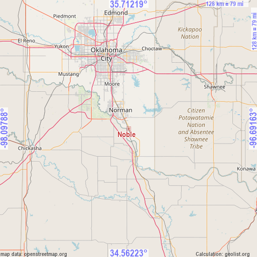
Noble GPS coordinates[2]
35° 8' 21.264" North, 97° 23' 41.1" West
| Map corner | latitude | longitude |
|---|---|---|
| Upper-left | 35.71219°, | -98.09788° |
| Center: | 35.13924°, | -97.39475° |
| Lower-right: | 34.56223°, | -96.69163° |
| Map W x H: | 127.9×127.9 km | = 79.5×79.5mi |
| max Lat: | 71.29058° ⇑74.6% North |
| Noble: | 35.13924° |
| min Lat: | ⇓25.4% South 19.06759° |
| min Long | Noble | max Long |
| -171.73463° | -97.39475° | -66.98998° |
| W 23.2%⇐ | ⇒76.8% E |
Elevation
Elevation of Noble is 367 m = 1204 ft, and this is 72.2 m = 237 ft above average elevation for this country.
| Max E: |
3189 m = 10463 ft | 18.8% |
| Noble | 367 m 1204 ft | |
| Avg. | 294.8 m = 967 ft | |
Min E: |
-60 m = -197 ft | 81.2% |
See also: United States elevation on elevation.city.
Geographical zone
Noble is located in North temperate zone (between Tropic of Cancer and the Arctic Circle). Distance of this Northern Tropic circle is 1301.2 km =808.5 mi to South.| Distance of | km | miles | from Noble |
|---|---|---|---|
| North Pole | 6099.9 | 3790.3 | to North |
| Arctic Circle | 3494.1 | 2171.1 | to North |
| Tropic Cancer | 1301.2 | 808.5 | to South |
| Equator | 3907.1 | 2427.8 | to South |


Nearby cities:
15 places around Noble: (largest is in red/bold)
• Blanchard
23.9 km =14.9 mi,  269°
269°
• Cole
16.7 km =10.4 mi,  255°
255°
• Dibble
24.4 km =15.2 mi,  241°
241°
• Goldsby
7.5 km =4.7 mi, 271°
• Hall Park
10.9 km =6.8 mi,  354°
354°
• Lexington
14.8 km =9.2 mi,  158°
158°
• Moore
23.8 km =14.8 mi,  339°
339°
• Newcastle
22.2 km =13.8 mi,  302°
302°
• Norman
10.1 km =6.3 mi, 336°
• Pink
28.4 km =17.6 mi,  61°
61°
• Purcell
14.3 km =8.9 mi,  167°
167°
• Slaughterville
7.9 km =4.9 mi,  136°
136°
• Valley Brook
30.3 km =18.8 mi, 344°
• Washington
12.1 km =7.5 mi,  222°
222°
• Wayne
25.6 km =15.9 mi, 163°
Sources, notices
• [Note1] Compared only with cities in United States existing in our database
• [Src1] Map data: © OpenStreetMap contributors (CC-BY-SA)
• [Src2] Other city data from geonames.org with taken over terms of usage.
• [Src3] Geographical zone / Annual Mean Temperature by Robert A. Rohde @ Wikipedia
