Norman geodata
Norman (Oklahoma) is a seat of a second-order administrative division; located in United States in America/Chicago (GMT-5) time zone. With population of 120,284 people, there are 261 cities with bigger population in this country. Compared to other cities in United States, 74.2% of cities are located further ↑North; 77% of cities are located further →East and 80.7% of cities have lower elevation than Norman. Note1


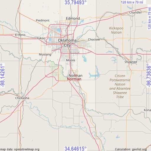
Norman GPS coordinates[2]
35° 13' 21.252" North, 97° 26' 22.128" West
| Map corner | latitude | longitude |
|---|---|---|
| Upper-left | 35.79493°, | -98.14261° |
| Center: | 35.22257°, | -97.43948° |
| Lower-right: | 34.64615°, | -96.73636° |
| Map W x H: | 127.7×127.7 km | = 79.3×79.3mi |
| max Lat: | 71.29058° ⇑74.2% North |
| Norman: | 35.22257° |
| min Lat: | ⇓25.8% South 19.06759° |
| min Long | Norman | max Long |
| -171.73463° | -97.43948° | -66.98998° |
| W 23%⇐ | ⇒77% E |
Elevation
Elevation of Norman is 361 m = 1184 ft, and this is 66.2 m = 217 ft above average elevation for this country.
| Max E: |
3189 m = 10463 ft | 19.3% |
| Norman | 361 m 1184 ft | |
| Avg. | 294.8 m = 967 ft | |
Min E: |
-60 m = -197 ft | 80.7% |
See also: Norman elevation on elevation.city.
Geographical zone
Norman is located in North temperate zone (between Tropic of Cancer and the Arctic Circle). Distance of this Northern Tropic circle is 1310.5 km =814.3 mi to South.| Distance of | km | miles | from Norman |
|---|---|---|---|
| North Pole | 6090.7 | 3784.6 | to North |
| Arctic Circle | 3484.8 | 2165.4 | to North |
| Tropic Cancer | 1310.5 | 814.3 | to South |
| Equator | 3916.4 | 2433.5 | to South |


Nearby cities:
15 places around Norman: (largest is in red/bold)
• Blanchard
22 km =13.7 mi,  244°
244°
• Cole
18 km =11.2 mi,  222°
222°
• Del City
24.4 km =15.2 mi,  359°
359°
• Dibble
27.2 km =16.9 mi, 219°
• Goldsby
9.7 km =6 mi,  200°
200°
• Hall Park
3.4 km =2.1 mi,  61°
61°
• Lexington
25 km =15.5 mi,  157°
157°
• Midwest City
25.5 km =15.8 mi,  8°
8°
• Moore
13.7 km =8.5 mi,  341°
341°
• Newcastle
14.8 km =9.2 mi,  280°
280°
• Noble
10.1 km =6.3 mi, 156°
• Purcell
24.3 km =15.1 mi, 162°
• Slaughterville
17.8 km =11.1 mi,  147°
147°
• Valley Brook
20.3 km =12.6 mi,  349°
349°
• Washington
18.6 km =11.6 mi,  192°
192°
Sources, notices
• [Note1] Compared only with cities in United States existing in our database
• [Src1] Map data: © OpenStreetMap contributors (CC-BY-SA)
• [Src2] Other city data from geonames.org with taken over terms of usage.
• [Src3] Geographical zone / Annual Mean Temperature by Robert A. Rohde @ Wikipedia
