Slaughterville geodata
Slaughterville (Oklahoma) is a populated place; located in United States in America/Chicago (GMT-5) time zone. With population of 4,217 people, there are 7957 cities with bigger population in this country. Compared to other cities in United States, 74.9% of cities are located further ↑North; 76.7% of cities are located further →East and 79% of cities have lower elevation than Slaughterville. Note1


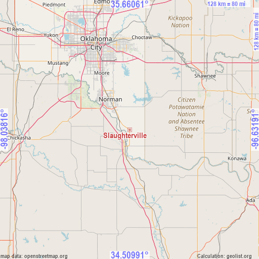
Slaughterville GPS coordinates[2]
35° 5' 14.244" North, 97° 20' 6.108" West
| Map corner | latitude | longitude |
|---|---|---|
| Upper-left | 35.66061°, | -98.03816° |
| Center: | 35.08729°, | -97.33503° |
| Lower-right: | 34.50991°, | -96.63191° |
| Map W x H: | 127.9×127.9 km | = 79.5×79.5mi |
| max Lat: | 71.29058° ⇑74.9% North |
| Slaughterville: | 35.08729° |
| min Lat: | ⇓25.1% South 19.06759° |
| min Long | Slaughterville | max Long |
| -171.73463° | -97.33503° | -66.98998° |
| W 23.3%⇐ | ⇒76.7% E |
Elevation
Elevation of Slaughterville is 344 m = 1129 ft, and this is 49.2 m = 161 ft above average elevation for this country.
| Max E: |
3189 m = 10463 ft | 21% |
| Slaughterville | 344 m 1129 ft | |
| Avg. | 294.8 m = 967 ft | |
Min E: |
-60 m = -197 ft | 79% |
See also: United States elevation on elevation.city.
Geographical zone
Slaughterville is located in North temperate zone (between Tropic of Cancer and the Arctic Circle). Distance of this Northern Tropic circle is 1295.4 km =804.9 mi to South.| Distance of | km | miles | from Slaughterville |
|---|---|---|---|
| North Pole | 6105.7 | 3793.9 | to North |
| Arctic Circle | 3499.8 | 2174.7 | to North |
| Tropic Cancer | 1295.4 | 804.9 | to South |
| Equator | 3901.3 | 2424.2 | to South |


Nearby cities:
15 places around Slaughterville: (largest is in red/bold)
• Blanchard
29.9 km =18.6 mi,  280°
280°
• Cole
21.7 km =13.5 mi,  274°
274°
• Dibble
27.5 km =17.1 mi,  257°
257°
• Goldsby
14.2 km =8.8 mi,  294°
294°
• Hall Park
17.9 km =11.1 mi,  338°
338°
• Lexington
8.1 km =5 mi,  180°
180°
• Maysville
30.7 km =19.1 mi,  192°
192°
• Newcastle
29.9 km =18.6 mi,  306°
306°
• Noble
7.9 km =4.9 mi,  316°
316°
• Norman
17.8 km =11.1 mi,  327°
327°
• Paoli
29.8 km =18.5 mi,  166°
166°
• Pink
27.5 km =17.1 mi,  45°
45°
• Purcell
8.5 km =5.3 mi,  196°
196°
• Washington
14 km =8.7 mi, 256°
• Wayne
18.9 km =11.7 mi, 174°
Sources, notices
• [Note1] Compared only with cities in United States existing in our database
• [Src1] Map data: © OpenStreetMap contributors (CC-BY-SA)
• [Src2] Other city data from geonames.org with taken over terms of usage.
• [Src3] Geographical zone / Annual Mean Temperature by Robert A. Rohde @ Wikipedia
