Ringling geodata
Ringling (Oklahoma) is a populated place; located in United States in America/Chicago (GMT-5) time zone. With population of 1,002 people, there are 16269 cities with bigger population in this country. Compared to other cities in United States, 79.1% of cities are located further ↑North; 77.4% of cities are located further →East and 68.9% of cities have lower elevation than Ringling. Note1


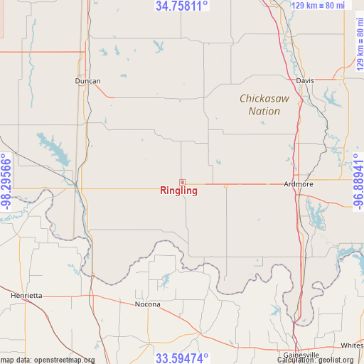
Ringling GPS coordinates[2]
34° 10' 42.348" North, 97° 35' 33.108" West
| Map corner | latitude | longitude |
|---|---|---|
| Upper-left | 34.75811°, | -98.29566° |
| Center: | 34.17843°, | -97.59253° |
| Lower-right: | 33.59474°, | -96.88941° |
| Map W x H: | 129.4×129.4 km | = 80.4×80.4mi |
| max Lat: | 71.29058° ⇑79.1% North |
| Ringling: | 34.17843° |
| min Lat: | ⇓20.9% South 19.06759° |
| min Long | Ringling | max Long |
| -171.73463° | -97.59253° | -66.98998° |
| W 22.6%⇐ | ⇒77.4% E |
Elevation
Elevation of Ringling is 280 m = 919 ft, and this is 14.8 m = 49 ft below average elevation for this country.
| Max E: |
3189 m = 10463 ft | 31.1% |
| Avg. | 294.8 m = 967 ft | |
| Ringling | 280 m = 919 ft | |
Min E: |
-60 m = -197 ft | 68.9% |
See also: United States elevation on elevation.city.
Geographical zone
Ringling is located in North temperate zone (between Tropic of Cancer and the Arctic Circle). Distance of this Northern Tropic circle is 1194.4 km =742.2 mi to South.| Distance of | km | miles | from Ringling |
|---|---|---|---|
| North Pole | 6206.8 | 3856.7 | to North |
| Arctic Circle | 3600.9 | 2237.5 | to North |
| Tropic Cancer | 1194.4 | 742.2 | to South |
| Equator | 3800.3 | 2361.4 | to South |


Nearby cities:
15 places around Ringling: (largest is in red/bold)
• Ardmore
41.3 km =25.7 mi,  90°
90°
• Comanche
40.2 km =25 mi,  301°
301°
• Duncan
49.2 km =30.6 mi,  317°
317°
• Empire City
48.1 km =29.9 mi, 303°
• Healdton
11.4 km =7.1 mi,  57°
57°
• Lone Grove
30.3 km =18.8 mi, 90°
• Marietta
51.4 km =31.9 mi,  121°
121°
• Meridian
44.9 km =27.9 mi,  308°
308°
• Nocona
45.3 km =28.1 mi,  195°
195°
• Nocona Hills
36.7 km =22.8 mi,  188°
188°
• Ryan
37.9 km =23.5 mi,  242°
242°
• Springer
44 km =27.3 mi,  69°
69°
• Velma
32.2 km =20 mi,  346°
346°
• Waurika
37.3 km =23.2 mi,  268°
268°
• Wilson
15.4 km =9.6 mi,  96°
96°
Sources, notices
• [Note1] Compared only with cities in United States existing in our database
• [Src1] Map data: © OpenStreetMap contributors (CC-BY-SA)
• [Src2] Other city data from geonames.org with taken over terms of usage.
• [Src3] Geographical zone / Annual Mean Temperature by Robert A. Rohde @ Wikipedia
