Ryan geodata
Ryan (Oklahoma) is a populated place; located in United States in America/Chicago (GMT-5) time zone. With population of 789 people, there are 17911 cities with bigger population in this country. Compared to other cities in United States, 80.1% of cities are located further ↑North; 78.4% of cities are located further →East and 69% of cities have lower elevation than Ryan. Note1


Ryan GPS coordinates[2]
34° 1' 12.36" North, 97° 57' 27.144" West
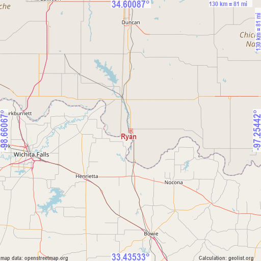
| Map corner | latitude | longitude |
|---|---|---|
| Upper-left | 34.60087°, | -98.66067° |
| Center: | 34.0201°, | -97.95754° |
| Lower-right: | 33.43533°, | -97.25442° |
| Map W x H: | 129.6×129.6 km | = 80.5×80.5mi |
| max Lat: | 71.29058° ⇑80.1% North |
| Ryan: | 34.0201° |
| min Lat: | ⇓19.9% South 19.06759° |
| min Long | Ryan | max Long |
| -171.73463° | -97.95754° | -66.98998° |
| W 21.6%⇐ | ⇒78.4% E |
Elevation
Elevation of Ryan is 281 m = 922 ft, and this is 13.8 m = 45 ft below average elevation for this country.
| Max E: |
3189 m = 10463 ft | 31% |
| Avg. | 294.8 m = 967 ft | |
| Ryan | 281 m = 922 ft | |
Min E: |
-60 m = -197 ft | 69% |
See also: United States elevation on elevation.city.
Geographical zone
Ryan is located in North temperate zone (between Tropic of Cancer and the Arctic Circle). Distance of this Northern Tropic circle is 1176.8 km =731.2 mi to South.| Distance of | km | miles | from Ryan |
|---|---|---|---|
| North Pole | 6224.4 | 3867.7 | to North |
| Arctic Circle | 3618.5 | 2248.4 | to North |
| Tropic Cancer | 1176.8 | 731.2 | to South |
| Equator | 3782.7 | 2350.5 | to South |


Nearby cities:
15 places around Ryan: (largest is in red/bold)
• Comanche
38.8 km =24.1 mi,  359°
359°
• Empire City
45 km =28 mi,  351°
351°
• Healdton
49.3 km =30.6 mi,  61°
61°
• Henrietta
31.5 km =19.6 mi,  224°
224°
• Meridian
45.3 km =28.1 mi, 357°
• Montague
45.2 km =28.1 mi,  151°
151°
• Nocona
33.6 km =20.9 mi,  140°
140°
• Nocona Hills
34 km =21.1 mi,  123°
123°
• Petrolia
25.3 km =15.7 mi,  268°
268°
• Ringling
37.9 km =23.5 mi, 62°
• Temple
38 km =23.6 mi,  317°
317°
• Walters
49.6 km =30.8 mi, 319°
• Waurika
16.7 km =10.4 mi, 347°
• Wichita Falls
50.8 km =31.6 mi,  256°
256°
• Wilson
51.4 km =31.9 mi,  72°
72°
Sources, notices
• [Note1] Compared only with cities in United States existing in our database
• [Src1] Map data: © OpenStreetMap contributors (CC-BY-SA)
• [Src2] Other city data from geonames.org with taken over terms of usage.
• [Src3] Geographical zone / Annual Mean Temperature by Robert A. Rohde @ Wikipedia
