Springer geodata
Springer (Oklahoma) is a populated place; located in United States in America/Chicago (GMT-5) time zone. With population of 702 people, there are 18655 cities with bigger population in this country. Compared to other cities in United States, 78.4% of cities are located further ↑North; 76.1% of cities are located further →East and 69.7% of cities have lower elevation than Springer. Note1


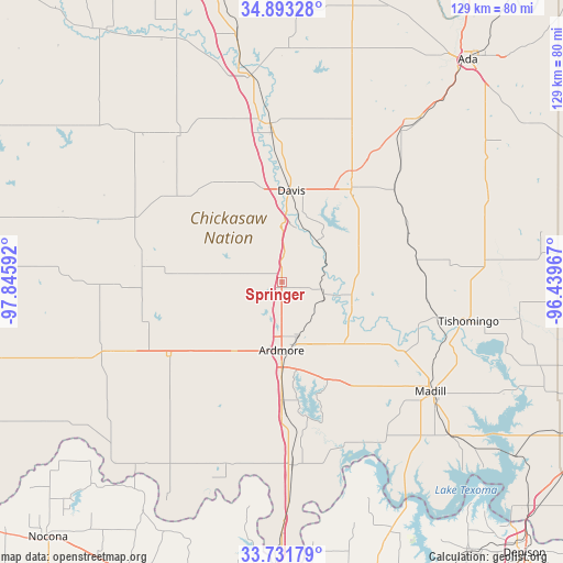
Springer GPS coordinates[2]
34° 18' 52.344" North, 97° 8' 34.044" West
| Map corner | latitude | longitude |
|---|---|---|
| Upper-left | 34.89328°, | -97.84592° |
| Center: | 34.31454°, | -97.14279° |
| Lower-right: | 33.73179°, | -96.43967° |
| Map W x H: | 129.1×129.1 km | = 80.2×80.2mi |
| max Lat: | 71.29058° ⇑78.4% North |
| Springer: | 34.31454° |
| min Lat: | ⇓21.6% South 19.06759° |
| min Long | Springer | max Long |
| -171.73463° | -97.14279° | -66.98998° |
| W 23.9%⇐ | ⇒76.1% E |
Elevation
Elevation of Springer is 284 m = 932 ft, and this is 10.8 m = 35 ft below average elevation for this country.
| Max E: |
3189 m = 10463 ft | 30.3% |
| Avg. | 294.8 m = 967 ft | |
| Springer | 284 m = 932 ft | |
Min E: |
-60 m = -197 ft | 69.7% |
See also: United States elevation on elevation.city.
Geographical zone
Springer is located in North temperate zone (between Tropic of Cancer and the Arctic Circle). Distance of this Northern Tropic circle is 1209.5 km =751.5 mi to South.| Distance of | km | miles | from Springer |
|---|---|---|---|
| North Pole | 6191.6 | 3847.3 | to North |
| Arctic Circle | 3585.8 | 2228.1 | to North |
| Tropic Cancer | 1209.5 | 751.5 | to South |
| Equator | 3815.4 | 2370.8 | to South |


Nearby cities:
15 places around Springer: (largest is in red/bold)
• Ardmore
15.6 km =9.7 mi,  180°
180°
• Davis
21.2 km =13.2 mi,  5°
5°
• Dickson
20.3 km =12.6 mi,  134°
134°
• Elmore City
41.4 km =25.7 mi,  325°
325°
• Healdton
33 km =20.5 mi,  254°
254°
• Lone Grove
19 km =11.8 mi,  215°
215°
• Madill
42.3 km =26.3 mi, 126°
• Mannsville
28 km =17.4 mi,  120°
120°
• Marietta
42 km =26.1 mi, 176°
• Oakland
40 km =24.9 mi, 126°
• Ravia
36.9 km =22.9 mi,  102°
102°
• Sulphur
26.8 km =16.7 mi,  36°
36°
• Tishomingo
43.5 km =27 mi, 101°
• Wilson
31.1 km =19.3 mi,  236°
236°
• Wynnewood
36.6 km =22.7 mi,  356°
356°
Sources, notices
• [Note1] Compared only with cities in United States existing in our database
• [Src1] Map data: © OpenStreetMap contributors (CC-BY-SA)
• [Src2] Other city data from geonames.org with taken over terms of usage.
• [Src3] Geographical zone / Annual Mean Temperature by Robert A. Rohde @ Wikipedia
