Temple geodata
Temple (Oklahoma) is a populated place; located in United States in America/Chicago (GMT-5) time zone. With population of 969 people, there are 16499 cities with bigger population in this country. Compared to other cities in United States, 78.6% of cities are located further ↑North; 78.9% of cities are located further →East and 74.5% of cities have lower elevation than Temple. Note1


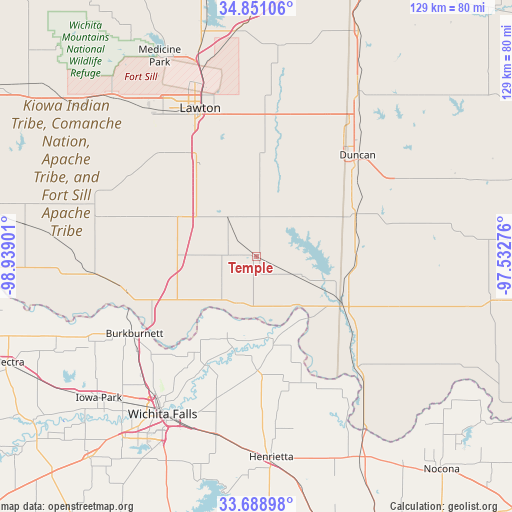
Temple GPS coordinates[2]
34° 16' 19.308" North, 98° 14' 9.168" West
| Map corner | latitude | longitude |
|---|---|---|
| Upper-left | 34.85106°, | -98.93901° |
| Center: | 34.27203°, | -98.23588° |
| Lower-right: | 33.68898°, | -97.53276° |
| Map W x H: | 129.2×129.2 km | = 80.3×80.3mi |
| max Lat: | 71.29058° ⇑78.6% North |
| Temple: | 34.27203° |
| min Lat: | ⇓21.4% South 19.06759° |
| min Long | Temple | max Long |
| -171.73463° | -98.23588° | -66.98998° |
| W 21.1%⇐ | ⇒78.9% E |
Elevation
Elevation of Temple is 310 m = 1017 ft, and this is 15.2 m = 50 ft above average elevation for this country.
| Max E: |
3189 m = 10463 ft | 25.5% |
| Temple | 310 m 1017 ft | |
| Avg. | 294.8 m = 967 ft | |
Min E: |
-60 m = -197 ft | 74.5% |
See also: United States elevation on elevation.city.
Geographical zone
Temple is located in North temperate zone (between Tropic of Cancer and the Arctic Circle). Distance of this Northern Tropic circle is 1204.8 km =748.6 mi to South.| Distance of | km | miles | from Temple |
|---|---|---|---|
| North Pole | 6196.4 | 3850.3 | to North |
| Arctic Circle | 3590.5 | 2231 | to North |
| Tropic Cancer | 1204.8 | 748.6 | to South |
| Equator | 3810.7 | 2367.9 | to South |


Nearby cities:
15 places around Temple: (largest is in red/bold)
• Burkburnett
36.4 km =22.6 mi,  237°
237°
• Central High
41.3 km =25.7 mi,  18°
18°
• Comanche
27.2 km =16.9 mi,  66°
66°
• Duncan
36.1 km =22.4 mi,  44°
44°
• Empire City
25.3 km =15.7 mi,  49°
49°
• Geronimo
26.9 km =16.7 mi,  329°
329°
• Grandfield
41.5 km =25.8 mi,  263°
263°
• Lawton
40 km =24.9 mi,  339°
339°
• Marlow
43.7 km =27.2 mi, 35°
• Meridian
29.3 km =18.2 mi, 53°
• Petrolia
28.8 km =17.9 mi,  179°
179°
• Ryan
38 km =23.6 mi,  137°
137°
• Walters
11.8 km =7.3 mi, 325°
• Waurika
24.8 km =15.4 mi,  118°
118°
• Wichita Falls
46.4 km =28.8 mi,  210°
210°
Sources, notices
• [Note1] Compared only with cities in United States existing in our database
• [Src1] Map data: © OpenStreetMap contributors (CC-BY-SA)
• [Src2] Other city data from geonames.org with taken over terms of usage.
• [Src3] Geographical zone / Annual Mean Temperature by Robert A. Rohde @ Wikipedia
