Cherry Tree geodata
Cherry Tree (Oklahoma) is a populated place; located in United States in America/Chicago (GMT-5) time zone. With population of 883 people, there are 17089 cities with bigger population in this country. Compared to other cities in United States, 71.6% of cities are located further ↑North; 70.3% of cities are located further →East and 77.5% of cities have lower elevation than Cherry Tree. Note1


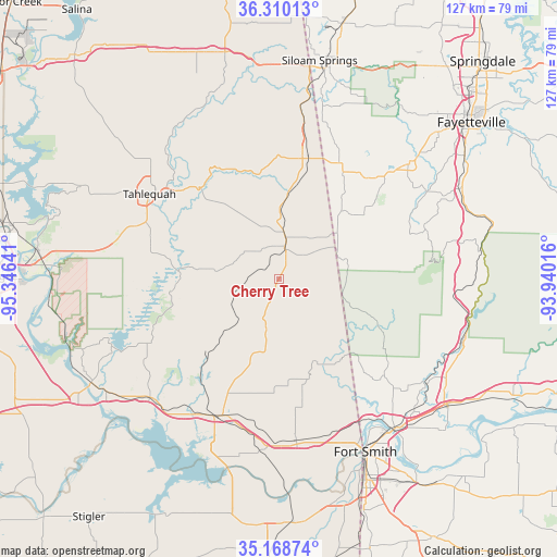
Cherry Tree GPS coordinates[2]
35° 44' 29.328" North, 94° 38' 35.808" West
| Map corner | latitude | longitude |
|---|---|---|
| Upper-left | 36.31013°, | -95.34641° |
| Center: | 35.74148°, | -94.64328° |
| Lower-right: | 35.16874°, | -93.94016° |
| Map W x H: | 126.9×126.9 km | = 78.9×78.9mi |
| max Lat: | 71.29058° ⇑71.6% North |
| Cherry Tree: | 35.74148° |
| min Lat: | ⇓28.4% South 19.06759° |
| min Long | Cherry Tree | max Long |
| -171.73463° | -94.64328° | -66.98998° |
| W 29.7%⇐ | ⇒70.3% E |
Elevation
Elevation of Cherry Tree is 332 m = 1089 ft, and this is 37.2 m = 122 ft above average elevation for this country.
| Max E: |
3189 m = 10463 ft | 22.5% |
| Cherry Tree | 332 m 1089 ft | |
| Avg. | 294.8 m = 967 ft | |
Min E: |
-60 m = -197 ft | 77.5% |
See also: United States elevation on elevation.city.
Geographical zone
Cherry Tree is located in North temperate zone (between Tropic of Cancer and the Arctic Circle). Distance of this Northern Tropic circle is 1368.2 km =850.2 mi to South.| Distance of | km | miles | from Cherry Tree |
|---|---|---|---|
| North Pole | 6033 | 3748.7 | to North |
| Arctic Circle | 3427.1 | 2129.5 | to North |
| Tropic Cancer | 1368.2 | 850.2 | to South |
| Equator | 3974.1 | 2469.4 | to South |


Nearby cities:
15 places around Cherry Tree: (largest is in red/bold)
• Bell
6.6 km =4.1 mi,  113°
113°
• Brushy
21.8 km =13.5 mi,  199°
199°
• Cedarville
31.4 km =19.5 mi,  127°
127°
• Fairfield
12.1 km =7.5 mi,  13°
13°
• Keys
29.9 km =18.6 mi,  282°
282°
• Lincoln
30.5 km =19 mi,  40°
40°
• Park Hill
31.4 km =19.5 mi,  295°
295°
• Pettit
29.2 km =18.1 mi, 275°
• Remy
33.2 km =20.6 mi,  162°
162°
• Sallisaw
33.9 km =21.1 mi, 202°
• Stilwell
8.2 km =5.1 mi, 9°
• Tahlequah
35.2 km =21.9 mi, 303°
• Tenkiller
21 km =13 mi,  288°
288°
• Welling
27.8 km =17.3 mi, 303°
• Westville
28.7 km =17.8 mi, 13°
Sources, notices
• [Note1] Compared only with cities in United States existing in our database
• [Src1] Map data: © OpenStreetMap contributors (CC-BY-SA)
• [Src2] Other city data from geonames.org with taken over terms of usage.
• [Src3] Geographical zone / Annual Mean Temperature by Robert A. Rohde @ Wikipedia
