Hanover geodata
Hanover (Pennsylvania) is a populated place; located in United States in America/New_York (GMT-4) time zone. With population of 15,496 people, there are 3144 cities with bigger population in this country. Compared to other cities in United States, 51.5% of cities are located further ↓South; 80.6% of cities are located further ←West and 52.8% of cities have higher elevation than Hanover. Note1


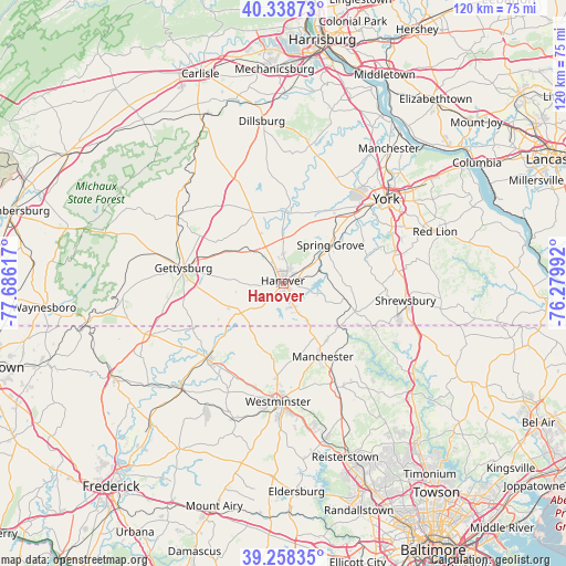
Hanover GPS coordinates[2]
39° 48' 2.376" North, 76° 58' 58.944" West
| Map corner | latitude | longitude |
|---|---|---|
| Upper-left | 40.33873°, | -77.68617° |
| Center: | 39.80066°, | -76.98304° |
| Lower-right: | 39.25835°, | -76.27992° |
| Map W x H: | 120.1×120.1 km | = 74.6×74.6mi |
| max Lat: | 71.29058° ⇑48.5% North |
| Hanover: | 39.80066° |
| min Lat: | ⇓51.5% South 19.06759° |
| min Long | Hanover | max Long |
| -171.73463° | -76.98304° | -66.98998° |
| W 80.6%⇐ | ⇒19.4% E |
Elevation
Elevation of Hanover is 188 m = 617 ft, and this is 106.8 m = 350 ft below average elevation for this country.
| Max E: |
3189 m = 10463 ft | 52.8% |
| Avg. | 294.8 m = 967 ft | |
| Hanover | 188 m = 617 ft | |
Min E: |
-60 m = -197 ft | 47.2% |
See also: United States elevation on elevation.city.
Geographical zone
Hanover is located in North temperate zone (between Tropic of Cancer and the Arctic Circle). Distance of this Northern Tropic circle is 1819.5 km =1130.6 mi to South.| Distance of | km | miles | from Hanover |
|---|---|---|---|
| North Pole | 5581.6 | 3468.2 | to North |
| Arctic Circle | 2975.8 | 1849.1 | to North |
| Tropic Cancer | 1819.5 | 1130.6 | to South |
| Equator | 4425.4 | 2749.8 | to South |


Nearby cities:
15 places around Hanover: (largest is in red/bold)
• Abbottstown
9.5 km =5.9 mi,  359°
359°
• Bonneauville
13.2 km =8.2 mi,  275°
275°
• East Berlin
15.2 km =9.4 mi,  1°
1°
• Hampton
15.7 km =9.8 mi,  335°
335°
• Jefferson
12.2 km =7.6 mi,  81°
81°
• Lake Heritage
17.2 km =10.7 mi,  273°
273°
• Littlestown
10.9 km =6.8 mi,  235°
235°
• Manchester
17.6 km =10.9 mi,  151°
151°
• McSherrystown
2.5 km =1.6 mi,  287°
287°
• Midway
1.9 km =1.2 mi,  297°
297°
• Mount Pleasant
10.9 km =6.8 mi,  226°
226°
• New Oxford
9.4 km =5.8 mi,  318°
318°
• Parkville
2.7 km =1.7 mi,  142°
142°
• Pennville
1.8 km =1.1 mi, 226°
• Spring Grove
12.9 km =8 mi,  50°
50°
Sources, notices
• [Note1] Compared only with cities in United States existing in our database
• [Src1] Map data: © OpenStreetMap contributors (CC-BY-SA)
• [Src2] Other city data from geonames.org with taken over terms of usage.
• [Src3] Geographical zone / Annual Mean Temperature by Robert A. Rohde @ Wikipedia
