Hilton Head geodata
Hilton Head (South Carolina) is a populated place; located in United States in America/New_York (GMT-4) time zone. With population of 37,099 people, there are 1314 cities with bigger population in this country. Compared to other cities in United States, 88.1% of cities are located further ↑North; 70.1% of cities are located further ←West and 93.9% of cities have higher elevation than Hilton Head. Note1


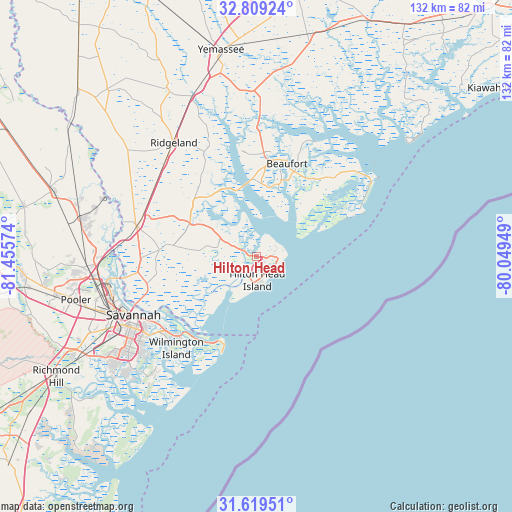
Hilton Head GPS coordinates[2]
32° 12' 58.752" North, 80° 45' 9.396" West
| Map corner | latitude | longitude |
|---|---|---|
| Upper-left | 32.80924°, | -81.45574° |
| Center: | 32.21632°, | -80.75261° |
| Lower-right: | 31.61951°, | -80.04949° |
| Map W x H: | 132.3×132.3 km | = 82.2×82.2mi |
| max Lat: | 71.29058° ⇑88.1% North |
| Hilton Head: | 32.21632° |
| min Lat: | ⇓11.9% South 19.06759° |
| min Long | Hilton Head | max Long |
| -171.73463° | -80.75261° | -66.98998° |
| W 70.1%⇐ | ⇒29.9% E |
Elevation
Elevation of Hilton Head is 10 m = 33 ft, and this is 284.8 m = 934 ft below average elevation for this country.
| Max E: |
3189 m = 10463 ft | 93.9% |
| Avg. | 294.8 m = 967 ft | |
| Hilton Head | 10 m = 33 ft | |
Min E: |
-60 m = -197 ft | 6.1% |
See also: United States elevation on elevation.city.
Geographical zone
Hilton Head is located in North temperate zone (between Tropic of Cancer and the Arctic Circle). Distance of this Northern Tropic circle is 976.2 km =606.6 mi to South.| Distance of | km | miles | from Hilton Head |
|---|---|---|---|
| North Pole | 6424.9 | 3992.2 | to North |
| Arctic Circle | 3819.1 | 2373.1 | to North |
| Tropic Cancer | 976.2 | 606.6 | to South |
| Equator | 3582.1 | 2225.8 | to South |


Nearby cities:
15 places around Hilton Head: (largest is in red/bold)
• Beaufort
25.2 km =15.7 mi,  18°
18°
• Bluffton
10.4 km =6.5 mi,  282°
282°
• Burton
24.5 km =15.2 mi,  6°
6°
• Hardeeville
31.8 km =19.8 mi, 284°
• Hilton Head Island
2.8 km =1.7 mi,  151°
151°
• Isle of Hope
39 km =24.2 mi,  228°
228°
• Laurel Bay
26.2 km =16.3 mi,  353°
353°
• Port Royal
19 km =11.8 mi, 17°
• Ridgeland
36.4 km =22.6 mi,  323°
323°
• Savannah
35.9 km =22.3 mi,  245°
245°
• Shell Point
18.7 km =11.6 mi,  4°
4°
• Thunderbolt
34.6 km =21.5 mi, 234°
• Tybee Island
25.6 km =15.9 mi,  200°
200°
• Whitemarsh Island
32.5 km =20.2 mi, 230°
• Wilmington Island
31.5 km =19.6 mi,  221°
221°
Sources, notices
• [Note1] Compared only with cities in United States existing in our database
• [Src1] Map data: © OpenStreetMap contributors (CC-BY-SA)
• [Src2] Other city data from geonames.org with taken over terms of usage.
• [Src3] Geographical zone / Annual Mean Temperature by Robert A. Rohde @ Wikipedia
